Monday, February 28, 2011
17 Mile Walk Round Sherwood Forest
I wanted to do a decent distance Saturday before tapering for the Belvoir Challenge, so remembered the John Merrill walk round the southern parts of Sherwood Forest I'd done in January 2009. It's 17 miles and starts (and finishes) near Blidworth. Whilst I was getting ready it was absolutely pouring, so I just resigned myself to getting wet and made a flask of coffee as a bit of a treat.
I remembered a few route finding difficulties from last time so managed to borrow a map from the library and this time I even found the right car park! There was only one other vehicle in it and I had to dodge some pretty huge puddles. By the time I followed the track into Blidworth and stopped at the Tesco Express to buy my lunch though the rain had stopped and that was pretty much it for the rest of the day.
The route leaves Blidworth by fields and follows them through a shallow valley but I thought that it would be extremely muddy so in an effort to keep my feet dry I decided to follow what I thought was a track which was part of the Robin Hood Way which ran roughly parallel. Had I looked at the map properly though I would have realised it was a minor road rather than a track and wouldn't have followed the footpath sign next to it which just brought me out further up the village! I followed part of the John Merrill route through some muddy fields before managing to cut across to the Robin Hood Way.
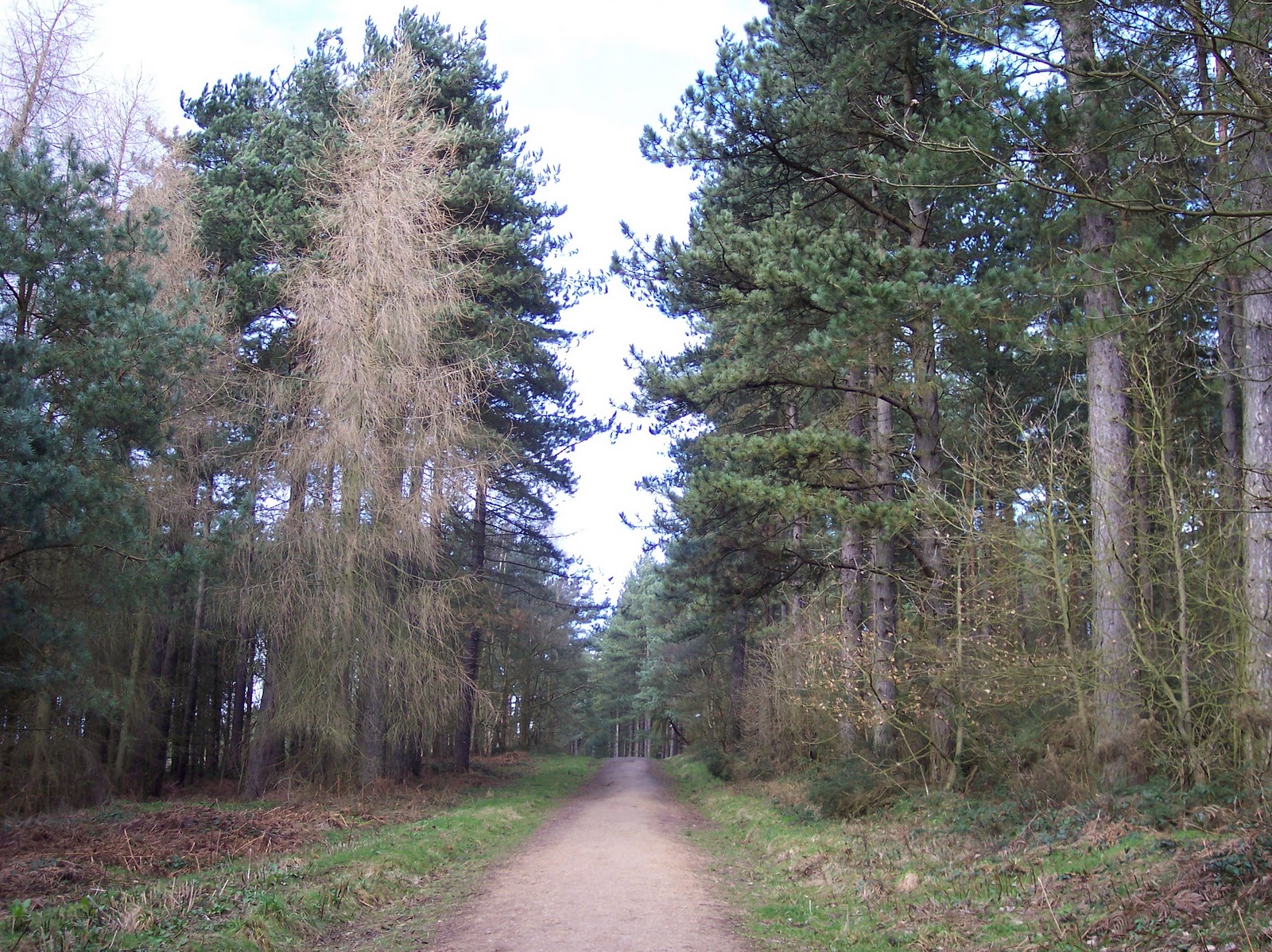
 Leaving Blidworth And The Distant Windfarm
The next part of the route followed a bridleway through fields towards Harlow Wood. I expected it to be muddy but it wasn't too bad... I managed to run and had an audience!


 The Sun Made An Appearance!
Walking through the village I picked up the path to the A60 which I'd followed in reverse during the Nottingham Ultra- only it was all uphill this way. I had another dash across the A60 before entering the grounds of the Park Hospital and Burnstump Country Park. My legs were feeling rather tired by this point but I was still managing to run a little- mainly downhill.
The latter stages of the walk are very pleasant, through Sansom and Blidworth forests.

I did get a little lost when trying to reach the car park at Blidworth Bottoms though. John Merrill instructed me to follow the main track, ignoring all turnings, and I'm sure I remembered doing just that before and ending up at the car park, but this time I was faced with a junction of tracks- none of which went particularly straight on. I was following a woman and her young son, and figured that they were likely to be heading to the car park too, so followed them to the left, only to see them stop and sit on a bench at the end of the track- which led into a field with no cars in sight...
I turned left, following a muddy horse track downhill which eventually led to the car park and the road. I was thinking that if it was muddy here then it's going to be hell on Saturday!
I saw loads of snow drops in the woods, there seemed to be a thick carpet of them in places- the sun had well and truly come out by now and it was the best part of the day.

I think that the best part of any event is the taper just before (and the rest afterwards!)
I remembered a few route finding difficulties from last time so managed to borrow a map from the library and this time I even found the right car park! There was only one other vehicle in it and I had to dodge some pretty huge puddles. By the time I followed the track into Blidworth and stopped at the Tesco Express to buy my lunch though the rain had stopped and that was pretty much it for the rest of the day.
The route leaves Blidworth by fields and follows them through a shallow valley but I thought that it would be extremely muddy so in an effort to keep my feet dry I decided to follow what I thought was a track which was part of the Robin Hood Way which ran roughly parallel. Had I looked at the map properly though I would have realised it was a minor road rather than a track and wouldn't have followed the footpath sign next to it which just brought me out further up the village! I followed part of the John Merrill route through some muddy fields before managing to cut across to the Robin Hood Way.

The next part of the route followed a bridleway through fields towards Harlow Wood. I expected it to be muddy but it wasn't too bad... I managed to run and had an audience!


The Wind Turbines
I stopped for a coffee in Harlow Wood, before attempting the death-defying dash across the A60. The next part of the route, through Thieves Wood, I remembered getting a bit wrong before but managed to follow the 'Great Way of the King' to the car park. I sat at a bench and got out my egg sandwiches and a coffee, feeling slightly guilty as there was a hot food and drinks van parked nearby!
I looked at the map and realised I still had quite a way to go so decided to press on, along good but slightly muddy tracks past Newstead Abbey;

The Abbey
After the Abbey there was a long section down tarmaced tracks, past a lodge and down into the village of Papplewick;

Walking through the village I picked up the path to the A60 which I'd followed in reverse during the Nottingham Ultra- only it was all uphill this way. I had another dash across the A60 before entering the grounds of the Park Hospital and Burnstump Country Park. My legs were feeling rather tired by this point but I was still managing to run a little- mainly downhill.
The latter stages of the walk are very pleasant, through Sansom and Blidworth forests.
I did get a little lost when trying to reach the car park at Blidworth Bottoms though. John Merrill instructed me to follow the main track, ignoring all turnings, and I'm sure I remembered doing just that before and ending up at the car park, but this time I was faced with a junction of tracks- none of which went particularly straight on. I was following a woman and her young son, and figured that they were likely to be heading to the car park too, so followed them to the left, only to see them stop and sit on a bench at the end of the track- which led into a field with no cars in sight...
I turned left, following a muddy horse track downhill which eventually led to the car park and the road. I was thinking that if it was muddy here then it's going to be hell on Saturday!
I saw loads of snow drops in the woods, there seemed to be a thick carpet of them in places- the sun had well and truly come out by now and it was the best part of the day.

The walk took me 6 hours, which I was quite pleased with- What with getting a bit lost I reckon it was nearer 18 miles anyway and has hopefully set me up ok for the Belvoir Challenge- I have certainly done my time wading through mud!
I think that the best part of any event is the taper just before (and the rest afterwards!)
Labels: Blidworth, Sherwood Forest
Saturday, February 19, 2011
Finally- Proper Training!
Since my last post I have actually been training more than I have done for ages! I have been to the gym and done a combination of speed work (well, slightly faster work) and hill work on the treadmill, and on Tuesday I ran for 5 miles on pavement which was much more than I had done for a long while. Still a long way to go but feels as though I'm getting there!
Last Friday I had the day off work, so walked down to Radcliffe-on-Trent to meet a colleague who wanted me to show her the cliff path. We walked the length of it but didn't cross the fields to the Trent as it was rather muddy- we walked back and paid a surprise call to an ex-colleague and had a look at the Devon Rex cats she breeds.
I jogged home and made up the distance by running round the lake at the watersports centre.
I woke up this morning knowing I had to do 13/ 14 miles today at least- it was absolutely pouring with rain, I could hear it dripping off the roof and hitting the ground. I really didn't want to go out but managed to find some motivation hiding somehwere (back of the wardrobe I think!) and, steeling my resolve, I braved the elements.
It wasn't too bad once I'd got out there- which is always the case- I decided on as mud-free route I could find as I didn't fancy getting caked, so set off up the canal, running and walking. I emerged near Cotgrave, and took a left towards Radcliffe, cutting up the byway connecting the A52 with the back road to Radcliffe past Holme Pierrepont.
It had actually stopped raining by now but was a bit chilly. I took a left down to the watersports centre and ran most of the way round the lake again- noticing quite a few cormorants gliding over the water. To make the route a bit further, I followed the Trent down under Lady Bay Bridge (part of the Robin Hood Marathon route) before following the intermittent path by the canal parellel with the A52. This was my least favourite part of the walk though as all I could hear was the constant roar of cars- makes you wonder where everyone is going!
I lengthened the route even more by walking up to Morrisons as I needed a few bits- fought my way around the store looking like god-knows-what, found a counter that wasn't too busy, plonked my stuff on the conveyer belt, took my bum bag off so that I could get my purse out to pay... purse? Oh b*gger! It's still in my hand bag at home!
I had to abandon my shopping and limp home empty handed...
The Belvoir Challenge is two weeks today and hopefully I have done enough to prepare for it- I am hoping that the rain holds off for a couple of weeks though to give the fields chance to dry out a bit!
Labels: Belvoir Challenge
Thursday, February 10, 2011
A Better Week!
I have not had too bad a week training wise! Last Friday my friend invited me round for takeway pizza, so I told myself that I could only go provided I put in a tough workout at the gym first (quite handy as the gym is on the way to my friends!)
I ran for 30 minutes, pushing the speed a little, then did 35 minutes on the elliptical, at quite high power levels. My fitness is not what it once was- the highest speed I managed on the treadmill was a singularly unimpressive 6mph and I found that tough!
Saturday was a marathon wedding shopping session. We did manage to get the bridesmaids dresses ordered, and Katie's shoes sorted, and I must have burnt a few calories trudging round Leicester for several hours (although we did stop for an essential cherry scone so maybe not...)
Sunday I decided to do a long walk in preparation for the Belvoir Challenge, so chose a route I'd done once before, ages ago, a 17 miler which starts at Burton Joyce, follows the Trent to Hazleford Ferry and the crosses fields and bridleways to Lambley and back to Burton Joyce.
Rather amazingly for me, I was up and walking by 9am, and I had the river path to myself when I set off. I got the camera out to take some pics for the blog and discovered that once again my batteries had failed- why do I never get any warning? So I have dug out some old pics just to brighten things up and give you all some idea.
I started off jogging, and managed to maintain it until Gunthorpe which I was quite pleased with as it was my first long outing for ages.
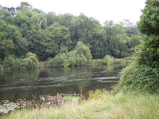 The River Trent Past Gunthorpe
It is usually quite busy at Gunthorpe, but I only saw one man with his young son, probably as it was still quite early and cloudy. I had a flask of coffee with me and decided that when I reached Hoveringham I'd take a little break.
I mostly ran the next few miles, with a little walking, until Hoveringham, where the river path follows the road for a little while before regaining the river as the road bends away to the left. I sat on a handy stone and had my cuppa- which was very welcome! Once I stopped I realised that it wasn't actually that warm. I set off, joined by a few dog walkers, and detoured slightly to inspect a new 'Lancaster' memorial which had been placed as a memorial to two planes that had crashed near to that spot during the second World War, only days apart, sadly killing all the crew who were only in their teens and 20's.
I managed to keep up my combination of running and walking a little (ok, less of a run and more of a shambling jog!) and by the time I reached Hazleford Ferry I had done 7 miles. The next part of the route followed a footpath from Bleasby village to Thurgarton- easy to follow luckily and taken mostly at a jog. Thurgarton is on the main road to Southwell and when I did this walk before I had problems finding the bridleway, but remembered where it was this time.
This was when the walk began to get a little soul destroying- the bridleway was quite muddy and fairly tough going. It zig-zagged its way up a hill and climbed for quite a while before a long drag to distant Souther Woods. Running was not an option so I fortified myself with a Snickers I'd found in the back of the cupboard and a cuppa when I reached the wood.
This part of the route had been confusing when I last did it, but I had the advantage of knowing where I was going this time. I passed a horse and rider- the horse leapt two feet into the air when it saw me- I didn't realise I looked quite so bad!
After this there was a downhill road stretch into Epperstone, which I managed to jog. Epperstone seems to be a pretty village.
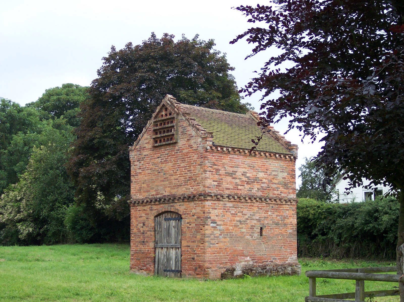
 Epperstone Dove Cote
A negotiation of fields and a busy road crossing brought me to Woodborough, I was feeling quite tired when I reached the bridleway, which, of course, was all uphill. I met a couple of friendly ladies on horses, who soon left me behind.
I was feeling quite tired now, and it seemed to be an endless uphill trudge. Finally I reached the outskirts of Lambley, passing a grass airstrip, windsock and one plane sitting beside an outbuilding- smallest airport I have ever seen- smaller even than the one at Coventry!
I reached a narrow fenced path skirting Lambley, a bit too narrow for comfort actually as I was almost touching the electric fence and had to walk leaning to the right! Following this was a lovely downhill path by a mysterious mound to the Nature Reserve at the bottom, where I sat on a bench and had my final cuppa.
The last part of the route, the bridleway back to Burton Joyce, goes very steeply uphill before dropping down into the village. I surprised myself by being able to run- although it was downhill!
Overall I felt quite strong and ran a lot more than I thought I would.
I ran another 3 miles on Tuesday and did intend to go out again last night but, erm, didn't... so I am off to the gym in a bit.
I am off work tomorrow so am walking with a colleague who wants to show me the cliff path in Radcliffe-on-Trent. It will make a nice change having someone to walk with, and as I am meeting her in Radcliffe I will walk there and back.
The Belvoir Challenge is just over three weeks away...
I ran for 30 minutes, pushing the speed a little, then did 35 minutes on the elliptical, at quite high power levels. My fitness is not what it once was- the highest speed I managed on the treadmill was a singularly unimpressive 6mph and I found that tough!
Saturday was a marathon wedding shopping session. We did manage to get the bridesmaids dresses ordered, and Katie's shoes sorted, and I must have burnt a few calories trudging round Leicester for several hours (although we did stop for an essential cherry scone so maybe not...)
Sunday I decided to do a long walk in preparation for the Belvoir Challenge, so chose a route I'd done once before, ages ago, a 17 miler which starts at Burton Joyce, follows the Trent to Hazleford Ferry and the crosses fields and bridleways to Lambley and back to Burton Joyce.
Rather amazingly for me, I was up and walking by 9am, and I had the river path to myself when I set off. I got the camera out to take some pics for the blog and discovered that once again my batteries had failed- why do I never get any warning? So I have dug out some old pics just to brighten things up and give you all some idea.
I started off jogging, and managed to maintain it until Gunthorpe which I was quite pleased with as it was my first long outing for ages.

It is usually quite busy at Gunthorpe, but I only saw one man with his young son, probably as it was still quite early and cloudy. I had a flask of coffee with me and decided that when I reached Hoveringham I'd take a little break.
I mostly ran the next few miles, with a little walking, until Hoveringham, where the river path follows the road for a little while before regaining the river as the road bends away to the left. I sat on a handy stone and had my cuppa- which was very welcome! Once I stopped I realised that it wasn't actually that warm. I set off, joined by a few dog walkers, and detoured slightly to inspect a new 'Lancaster' memorial which had been placed as a memorial to two planes that had crashed near to that spot during the second World War, only days apart, sadly killing all the crew who were only in their teens and 20's.
I managed to keep up my combination of running and walking a little (ok, less of a run and more of a shambling jog!) and by the time I reached Hazleford Ferry I had done 7 miles. The next part of the route followed a footpath from Bleasby village to Thurgarton- easy to follow luckily and taken mostly at a jog. Thurgarton is on the main road to Southwell and when I did this walk before I had problems finding the bridleway, but remembered where it was this time.
This was when the walk began to get a little soul destroying- the bridleway was quite muddy and fairly tough going. It zig-zagged its way up a hill and climbed for quite a while before a long drag to distant Souther Woods. Running was not an option so I fortified myself with a Snickers I'd found in the back of the cupboard and a cuppa when I reached the wood.
This part of the route had been confusing when I last did it, but I had the advantage of knowing where I was going this time. I passed a horse and rider- the horse leapt two feet into the air when it saw me- I didn't realise I looked quite so bad!
After this there was a downhill road stretch into Epperstone, which I managed to jog. Epperstone seems to be a pretty village.
A negotiation of fields and a busy road crossing brought me to Woodborough, I was feeling quite tired when I reached the bridleway, which, of course, was all uphill. I met a couple of friendly ladies on horses, who soon left me behind.
I was feeling quite tired now, and it seemed to be an endless uphill trudge. Finally I reached the outskirts of Lambley, passing a grass airstrip, windsock and one plane sitting beside an outbuilding- smallest airport I have ever seen- smaller even than the one at Coventry!
I reached a narrow fenced path skirting Lambley, a bit too narrow for comfort actually as I was almost touching the electric fence and had to walk leaning to the right! Following this was a lovely downhill path by a mysterious mound to the Nature Reserve at the bottom, where I sat on a bench and had my final cuppa.
The last part of the route, the bridleway back to Burton Joyce, goes very steeply uphill before dropping down into the village. I surprised myself by being able to run- although it was downhill!
Overall I felt quite strong and ran a lot more than I thought I would.
I ran another 3 miles on Tuesday and did intend to go out again last night but, erm, didn't... so I am off to the gym in a bit.
I am off work tomorrow so am walking with a colleague who wants to show me the cliff path in Radcliffe-on-Trent. It will make a nice change having someone to walk with, and as I am meeting her in Radcliffe I will walk there and back.
The Belvoir Challenge is just over three weeks away...
Labels: Belvoir Challenge, Burton Joyce, Epperstone
![]()
