Tuesday, March 27, 2012
The Charnwood Marathon- Event Report
I very nearly didn't get to the start of this one, as I came down with a bad chest and nasty cough the week before, but as I felt much better Friday night I decided to have a go and take it easy (plus the fact that I had already paid to do it and I don't like wasting money!) These events are certainly becoming more and more popular lately- I had been tempted to enter on the day, but then decided to get an entry in just in case and I'm glad I did as when I just went onto the web site to check whether the results were there yet the event was full!
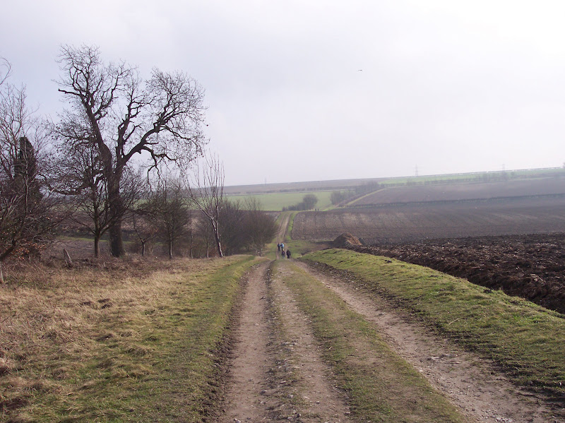
It had been lovely a couple of days beforehand but as I drove to Quorn it was really foggy and quite chilly. I parked in Rawlins School as directed and checked in at the village hall, grabbing a cuppa. We were set on our way by the town crier in full regalia- as we set off Ross from the Glassback Chronicles came over and we walked together. It makes the day so much easier having someone to chat to for 26 miles and we walk at the same pace (although I am sure I was slower than him Saturday so hope I didn't slow him up too much!)
There are some lovely views on this walk, which takes in the best of the Charnwood area of Leicestershire, but some of these were obscured by the mist. In fact some of the runners got a bit lost but luckily I remembered some of the route from before. We walked through fields and tracks through the village of Woodhouse Eves before climbing to Broombriggs Hill and the first self clip checkpoint.
 Not Gorillas, but Cows In The Mist
This was followed by a long steady climb to the top of Beacon Hill- no view today though- and dropped down through the trees to the first manned checkpoint and the point where the long and short routes split- we did see a guy dressed as a buffalo doing the shorter route!
 Beacon Hill
The runners were streaming past now, as we faced another quite steep climb before dropping down through fields to a farm. We could hear, but not see, the M1 quite close by which was quite eerie.
 Which Way?
At this point, the route climbs again before descending through Lubcloud Farm to the road and again we were cheated out of what is usually a lovely view! There was a stretch of road walking, which was a bit hairy as it was obvious that this was a fast road and some people did not see any reason to lower their speed or give us any room!
By the time we reached Blackbrook Reservoir and climbed through the trees towards Mount St Bernards Abbey, the mist was starting to clear and the sun was peeking through. It was also getting hot!
 Blackbrook Reservoir
Luckily there was a checkpoint at the Abbey with cake and a loo- luxury!! As we walked away I realised it was now really warm and sunny- a perfect spring day...
 Mount St Bernards Abbey
I had been a little worried how I'd feel, but I felt ok, apart from the usual pain in the side of my left foot which came on after around 15 miles. It's an odd kind of pain, right on the edge of the bones making up the arch of the foot and is quite localised, and usually hangs around for a day or two after, very frustrating.
The next part of the route is lovely, over the Charnwood Hills, moorland in miniature. We could see the next summit- Bardon Hill, the highest point in Leicestershire- looming in the distance.
 Charnwood Hills
It was so hot as we toiled up Bardon Hill- a lovely steep climb in the heat and there is a self clip right on the trig point at the summit so cheating is not an option... as if we would want to...
 View Of The Quarry From The Summit
The next part of the route I know quite well, down past Old Rise Rocks and through fields to the M1 and Copt Oak.
 Old Rise Rocks
 Descending To Copt Oak
I remembered that the checkpoint at Copt Oak usually has sandwiches, coffee and other goodies and hoped that we weren't going to be disappointed... we weren't! I managed to grab the last cheese roll and we sat and drank coffee in the churchyard and looking at the church where my sister was married last July (which happened to be the wettest day of the whole summer unfortunately- a total contrast to today!)
 Copt Oak Church
We left the church yard to the annoying sounds of a motorbike being ridden repeatedly round and round a nearby field (why!?) passing a herd of very muscular cows and descending towards Ulverscroft Priory (sadly in ruins). We passed a very excuberant group of girl backpackers on the way...
 Ulverscroft Priory Ruins
After a bit of fairly quiet road walking the route took us across fields towards the tourist trap village of Newtown Linford with its lovely thatched cottages. It would be a lovely place to live but unfortunately Bradgate Park has given it a bit of a traffic problem.

 Newtown Linford
As expected, Bradgate Park (childhood home of the ill-fated Lady Jane Grey) was really busy, but the majority of people tend to stick to the tarmac road running through the park so the higher you climb the quieter it gets. And climb we did, as of course there was a self clip on the Old John tower- the highest point of the park... my legs were protesting at this point and my feet felt as though they could do with pumping back up!

 The War Memorial
 Old John Tower
 Fallow Deer
There is another welcome checkpoint- with coffee and the obiglatory hot cross buns at the Hallgates end of Bradgate, and from then on it was just a case of following the route through Swithland Woods, more fields and then the track back to Quorn. As usual there was lovely soup on offer- I had the spicy parsnip- but I had to dash off as I was seeing my sister swim in a gala at Loughborough so didn't get the chance to savour another bowl full- maybe next year!!
It had been lovely a couple of days beforehand but as I drove to Quorn it was really foggy and quite chilly. I parked in Rawlins School as directed and checked in at the village hall, grabbing a cuppa. We were set on our way by the town crier in full regalia- as we set off Ross from the Glassback Chronicles came over and we walked together. It makes the day so much easier having someone to chat to for 26 miles and we walk at the same pace (although I am sure I was slower than him Saturday so hope I didn't slow him up too much!)
There are some lovely views on this walk, which takes in the best of the Charnwood area of Leicestershire, but some of these were obscured by the mist. In fact some of the runners got a bit lost but luckily I remembered some of the route from before. We walked through fields and tracks through the village of Woodhouse Eves before climbing to Broombriggs Hill and the first self clip checkpoint.

This was followed by a long steady climb to the top of Beacon Hill- no view today though- and dropped down through the trees to the first manned checkpoint and the point where the long and short routes split- we did see a guy dressed as a buffalo doing the shorter route!

The runners were streaming past now, as we faced another quite steep climb before dropping down through fields to a farm. We could hear, but not see, the M1 quite close by which was quite eerie.

At this point, the route climbs again before descending through Lubcloud Farm to the road and again we were cheated out of what is usually a lovely view! There was a stretch of road walking, which was a bit hairy as it was obvious that this was a fast road and some people did not see any reason to lower their speed or give us any room!
By the time we reached Blackbrook Reservoir and climbed through the trees towards Mount St Bernards Abbey, the mist was starting to clear and the sun was peeking through. It was also getting hot!

Luckily there was a checkpoint at the Abbey with cake and a loo- luxury!! As we walked away I realised it was now really warm and sunny- a perfect spring day...

I had been a little worried how I'd feel, but I felt ok, apart from the usual pain in the side of my left foot which came on after around 15 miles. It's an odd kind of pain, right on the edge of the bones making up the arch of the foot and is quite localised, and usually hangs around for a day or two after, very frustrating.
The next part of the route is lovely, over the Charnwood Hills, moorland in miniature. We could see the next summit- Bardon Hill, the highest point in Leicestershire- looming in the distance.

It was so hot as we toiled up Bardon Hill- a lovely steep climb in the heat and there is a self clip right on the trig point at the summit so cheating is not an option... as if we would want to...

The next part of the route I know quite well, down past Old Rise Rocks and through fields to the M1 and Copt Oak.


I remembered that the checkpoint at Copt Oak usually has sandwiches, coffee and other goodies and hoped that we weren't going to be disappointed... we weren't! I managed to grab the last cheese roll and we sat and drank coffee in the churchyard and looking at the church where my sister was married last July (which happened to be the wettest day of the whole summer unfortunately- a total contrast to today!)

We left the church yard to the annoying sounds of a motorbike being ridden repeatedly round and round a nearby field (why!?) passing a herd of very muscular cows and descending towards Ulverscroft Priory (sadly in ruins). We passed a very excuberant group of girl backpackers on the way...

After a bit of fairly quiet road walking the route took us across fields towards the tourist trap village of Newtown Linford with its lovely thatched cottages. It would be a lovely place to live but unfortunately Bradgate Park has given it a bit of a traffic problem.


As expected, Bradgate Park (childhood home of the ill-fated Lady Jane Grey) was really busy, but the majority of people tend to stick to the tarmac road running through the park so the higher you climb the quieter it gets. And climb we did, as of course there was a self clip on the Old John tower- the highest point of the park... my legs were protesting at this point and my feet felt as though they could do with pumping back up!


There is another welcome checkpoint- with coffee and the obiglatory hot cross buns at the Hallgates end of Bradgate, and from then on it was just a case of following the route through Swithland Woods, more fields and then the track back to Quorn. As usual there was lovely soup on offer- I had the spicy parsnip- but I had to dash off as I was seeing my sister swim in a gala at Loughborough so didn't get the chance to savour another bowl full- maybe next year!!
Labels: Charnwood Marathon
Friday, March 16, 2012
Plodding On...
I haven't got an event planned this weekend, my next event is next Saturday's Charnwood Marathon which I haven't done since 2008 I think...
I have had some cashflow problems this month, so put off entering some events- with the result that some of the events I planned to do are full! Ah well, it's my own fault, it's good to see that these events are so popular as this means that the sport can only grow in future...
I have been training (honest!!) I have been building the running back up to around 3-4 miles at once interspersed with walking. The amount of time spent running has been getting longer and so far so good; no knee problems. I have also been walking and going to the gym so feels like I am getting back on track quite nicely.
Tomorrow I am planning on a 14-16 miler, possibly starting from Radcliffe-On-Trent, and then onto Shelford, East Bridgford, along the path at the top of the cliffs above the River Trent, and back to Radcliffe-On-Trent, Sunday will be a rest day as I will be cooking my mum lunch and finding a goldfish for her from somewhere (bizarrely enough this is what she wants for her present since the fish they had outside died!! Beats the usual flowers and chocolates I suppose...)
Hope everyone has a great weekend...
Labels: training
Sunday, March 04, 2012
Golden Fleece Circuit- Event Report
This was a brand new challenge event run by the South Cave Scouts Group in East Yorkshire in memory of Bob Gunby, chairman of the Scout Group and keen walker. Bob sadly died in 2010 and so the event has been set up in his memory to raise money for the Scout Club. I was quite keen to do it as it's a part of the country I've not walked in before, plus it is a new county ticked off, so I stumbled out of bed at 5:30am and pointed the car towards Hull for the one and a half hour drive.
New events can struggle to get much interest and I have entered a few before which have been cancelled for this reason, so I wasn't sure what the turn out would be. I found the start by asking a large group of walkers for directions, and parked up in the grounds of South Cave castle as directed. I was immediately struck by all the people- loads and loads of walkers, most looking very seasoned and serious!! I walked into the Family Centre to register and the queue snaked back towards the door- I heard someone say later that they had had over 300 entrants, which is more than a lot of established events get, so I am sure that this will become an annual event.
After registering (I was given a tally card, a little wooden disc with my number on which I wasn't quite sure what was for, and the last colour photo copied map) I had just enough time to gulp down a hot coffee before we were urged outside for an 8:30am start. The chap started us off by talking about Bob, then started discussing the route until he was interrupted by a broad East Yorkshire voice from the crowd shouting 'Can't we go?'
We set off down through South Cave, and as we turned off on a track I saw a marshall holding a bowl and realised he was collecting the wooden discs. The first village was soon reached- Everthorpe- where our numbers were taken and tally cards clipped. It was very misty and grey; the gentle slopes of the Yorkshire Wolds were hidden from us in the mist. The field gradually started to spread out, and we passed through North Cave and then on a road through Hotham Park.
 Hotham Hall
I soon learnt that the Wolds largely consist of huge arable fields with tracks running through them, often for miles, and that when the route description instructed to 'turn left onto track towards village' the village could be quite some distance away!
The second checkpoint, offering juice and water, was next to Hotham Church with its curiously squat, square tower;
 Hotham Curch
The route then entered the rather muddy Houghton Woods, leaving them on a track, which became a road- which seemed to go on for ever uphill- to North Newbald and the third checkpoint. I knew I was in Yorkshire as from this point on, all the checkpoints had a large (and I mean large!) pot of tea permanently on the boil! This was the point where the longer and shorter routes split, and unusually most people seemed to be doing the 26.5 miles.
The route climbed out of the village before descending through a dale and joining the Yorkshire Wolds way. It was still very misty, rather windy and tried to rain a few times- the scenery would probably have been lovely in the sun, but at the moment it seemed a bit bleak!
 Walking Through The Dale
I arrived at Newbald Lodge and checkpoint 6 (I hadn't missed out a couple- I think checkpoints 4 and 5 were on the shorter route!!) One of the chaps here told us that on a clear day from a spot nearby, the Humber estuary, both power stations and York Minster could be seen... not today though unfortunately... I lingered for a bit over a hot cup of tea and found a handy spot out of the wind, next to the jam sandwiches and chocolate fingers.
There was a little confusion over which path to take after the checkpoint as the route description was rather sketchy at this point. I studied the map and set off on what I thought was the right path, letting two chaps overtake me so I could follow them! As we followed the track through more fields, and then onto a tarmac track which became a road, it started to rain, but luckily it didn't come to much and stopped just as I was on the point of debating whether to stop and put my waterproofs on. The route did a right turn at the village of Bishop Burton, heading up hill and along another track towards Walkington (quite aptly named given what we were doing!)
 Celebrations At The Farm?
There was some gorgeous flapjack on offer at checkpoint 7 at Walkington, and the weather actually looked as though it was going to brighten up a bit. I am not sure if I actually followed the correct route through and out of Walkington but I managed to get on the right path, partly by looking at the map and partly by following a group of walkers who had been in the pub for a swift pint. Walking along the pavements in the villages I kept seeing odd little yellow blobs, and it was only when I stopped and peered at one more closely that I realised it was neat little stencil as a reminder for dog owners;
 It was really sunny now as the route followed a roller coaster of a track through Risby Park Farm, and the Wolds were revealed in a much more flattering light- suddenly everything seemed a lot less bleak and much more picturesque. It was starting to take its toll on my legs though and I had a dull pain in the inside arch of my left foot- which I am still feeling today. I think that the Belvoir Challenge must have still been having an effect.
 Wolds Scenery
I must say the next part of the route was probably the worst for me. After Skidby the route followed a road for 3.5 kilometers, which became a muddy track- not only was it a little boring, but it was constantly climbing steadily uphill. I was glad to leave it and drop down to checkpoint 8 at York Grounds Farm. A lady was manning this with her two daughters, who were carrying out their tally clipping duties with great enthusiasm and generally having a whale of a time playing in the mud. I sat down for a few minutes, relishing a cup of tea and slice of swiss roll, in an attempt to refresh my weary legs for the last bit of the walk.
I reluctantly heaved myself up and set off along the track, and was rewarded with the site of the top of the Humber Bridge above the skyline in the distance- which you can't see in the photo!
 There was quite a lot more muddy track, predictably going uphill, but the view over the Humber estuary from the top almost made up for it!
 Wolds Way
 The Humber Estuary
There was a very welcome steep descent (which I managed to jog) towards Brantingham and its lovely church;
 Brantingham Church
I followed the road out of the vale, reaching the turn off for South Cave and checkpoint 9, which was a self clip hung on the gate. My legs would have been grateful to finish at this point but there was another nasty surprise in store...
 A very steep climb to Mount Airy Farm which left me panting and cursing, although I did actually overtake some people which is pretty good for me...
The last bit was an easy descent back into South Cave, walking through the village past the castle and the finish. The weather was lovely now, it was difficult to believe it was the same day as when we set out this morning! Looking out of the window now I'm glad this event was yesterday and not today!
 South Cave
 The Castle
My official time was 8 hours 16 minutes, which wasn't too bad- there was bean stew on offer which was tasty and filling, plus a good selection of cakes. In all, it was a good day, I am sure that this will become an annual event as I heard someone say it is definitely going to be run again next year.
I have a bit of a break now before the Charnwood Marathon on 24th March...
New events can struggle to get much interest and I have entered a few before which have been cancelled for this reason, so I wasn't sure what the turn out would be. I found the start by asking a large group of walkers for directions, and parked up in the grounds of South Cave castle as directed. I was immediately struck by all the people- loads and loads of walkers, most looking very seasoned and serious!! I walked into the Family Centre to register and the queue snaked back towards the door- I heard someone say later that they had had over 300 entrants, which is more than a lot of established events get, so I am sure that this will become an annual event.
After registering (I was given a tally card, a little wooden disc with my number on which I wasn't quite sure what was for, and the last colour photo copied map) I had just enough time to gulp down a hot coffee before we were urged outside for an 8:30am start. The chap started us off by talking about Bob, then started discussing the route until he was interrupted by a broad East Yorkshire voice from the crowd shouting 'Can't we go?'
We set off down through South Cave, and as we turned off on a track I saw a marshall holding a bowl and realised he was collecting the wooden discs. The first village was soon reached- Everthorpe- where our numbers were taken and tally cards clipped. It was very misty and grey; the gentle slopes of the Yorkshire Wolds were hidden from us in the mist. The field gradually started to spread out, and we passed through North Cave and then on a road through Hotham Park.

I soon learnt that the Wolds largely consist of huge arable fields with tracks running through them, often for miles, and that when the route description instructed to 'turn left onto track towards village' the village could be quite some distance away!
The second checkpoint, offering juice and water, was next to Hotham Church with its curiously squat, square tower;

The route then entered the rather muddy Houghton Woods, leaving them on a track, which became a road- which seemed to go on for ever uphill- to North Newbald and the third checkpoint. I knew I was in Yorkshire as from this point on, all the checkpoints had a large (and I mean large!) pot of tea permanently on the boil! This was the point where the longer and shorter routes split, and unusually most people seemed to be doing the 26.5 miles.
The route climbed out of the village before descending through a dale and joining the Yorkshire Wolds way. It was still very misty, rather windy and tried to rain a few times- the scenery would probably have been lovely in the sun, but at the moment it seemed a bit bleak!

I arrived at Newbald Lodge and checkpoint 6 (I hadn't missed out a couple- I think checkpoints 4 and 5 were on the shorter route!!) One of the chaps here told us that on a clear day from a spot nearby, the Humber estuary, both power stations and York Minster could be seen... not today though unfortunately... I lingered for a bit over a hot cup of tea and found a handy spot out of the wind, next to the jam sandwiches and chocolate fingers.
There was a little confusion over which path to take after the checkpoint as the route description was rather sketchy at this point. I studied the map and set off on what I thought was the right path, letting two chaps overtake me so I could follow them! As we followed the track through more fields, and then onto a tarmac track which became a road, it started to rain, but luckily it didn't come to much and stopped just as I was on the point of debating whether to stop and put my waterproofs on. The route did a right turn at the village of Bishop Burton, heading up hill and along another track towards Walkington (quite aptly named given what we were doing!)

There was some gorgeous flapjack on offer at checkpoint 7 at Walkington, and the weather actually looked as though it was going to brighten up a bit. I am not sure if I actually followed the correct route through and out of Walkington but I managed to get on the right path, partly by looking at the map and partly by following a group of walkers who had been in the pub for a swift pint. Walking along the pavements in the villages I kept seeing odd little yellow blobs, and it was only when I stopped and peered at one more closely that I realised it was neat little stencil as a reminder for dog owners;

I must say the next part of the route was probably the worst for me. After Skidby the route followed a road for 3.5 kilometers, which became a muddy track- not only was it a little boring, but it was constantly climbing steadily uphill. I was glad to leave it and drop down to checkpoint 8 at York Grounds Farm. A lady was manning this with her two daughters, who were carrying out their tally clipping duties with great enthusiasm and generally having a whale of a time playing in the mud. I sat down for a few minutes, relishing a cup of tea and slice of swiss roll, in an attempt to refresh my weary legs for the last bit of the walk.
I reluctantly heaved myself up and set off along the track, and was rewarded with the site of the top of the Humber Bridge above the skyline in the distance- which you can't see in the photo!


There was a very welcome steep descent (which I managed to jog) towards Brantingham and its lovely church;

I followed the road out of the vale, reaching the turn off for South Cave and checkpoint 9, which was a self clip hung on the gate. My legs would have been grateful to finish at this point but there was another nasty surprise in store...

The last bit was an easy descent back into South Cave, walking through the village past the castle and the finish. The weather was lovely now, it was difficult to believe it was the same day as when we set out this morning! Looking out of the window now I'm glad this event was yesterday and not today!

My official time was 8 hours 16 minutes, which wasn't too bad- there was bean stew on offer which was tasty and filling, plus a good selection of cakes. In all, it was a good day, I am sure that this will become an annual event as I heard someone say it is definitely going to be run again next year.
I have a bit of a break now before the Charnwood Marathon on 24th March...
Labels: golden fleece circuit
![]()
