Wednesday, August 15, 2012
Norfolk Coast Path- Day One
Sorry I'm a bit late updating this! My last entry finished with me ensconced in the B and B in Hunstanton, contemplating the rather ruinous state of my feet and my swollen ankle...
Saturday morning I reinforced the compeed dressing with zinc oxide tape and headed down for a hearty breakfast. I was joined by a couple who told me that this was their fourth visit to the B and B; their first visit coincided with a hotel inspector's visit, and they were rather perturbed when he pulled out a metal probe and proceeded to check the temperature of his breakfast sausage!
The owners had kindly dried my shoes for me, and as my comfy socks were still wet I had to put on a pair of the new ones, but hoped that the dressing would keep them from rubbing too much. As I took my first tentative steps, the blisters and the ankle didn't feel too bad, and I hoped I was going to be able to keep my feet dry!
I reached the signpost marking the start of the Norfolk Coast Path;
 I now faced retracing my steps to the end of the Peddars Way at Holme-Next-The-Sea, and recalling the agony of crossing the dunes the night before, I toyed with the idea of trying to find an inland path, but being a bit of a purist ended up walking the signed path- the dunes weren't quite so bad with dry feet!
I was still glad to see the now familiar sign post and stopped to fill my water bottle before heading away over the dunes on a track which soon became a boardwalk.
 The track followed the line of the dunes and sea defenses, past Gore Point to a small copse of fir trees, where I bought an ice lolly from the Nature Reserve. From here the boardwalks led through the mud flats near Thornham, popular with twitchers; I saw a couple of oyster catchers which you may just be able to make out below;
 Oyster Catchers!
Thornham used to be a thriving port before it silted up and became un-navigable, and the old wooden posts and parts of jetties can still be seen rising out of the marsh like the ghosts of a prosperous past.
 The Remains Of The Old Port
After Thornham the route turned inland, and followed a surprisingly busy road uphill for over a mile, before turning left through fields. It was dry but rather dull, and I must say this was the worst part of the day for me. I caught up and passed three walkers and eventually reached the pretty village of Brancaster. My feet were aching and I could have really done with a coffee, but was not yet half way so was determined to press on for as long as I could.
Finally I was walking near to the sea again, which lifted my spirits a little, on a boardwalk over marshy ground at the back of the village. This ran all the way to Brancaster Staithe;
 As the route passed by the Roman fort of Branodunum I decided to forget my sore feet and take a look at this unique slice of history. Unfortunately there was not a lot to see- just a field and an information board.
Brancaster Staithe appears to have a working port and boasts a cluster of run down sheds, a 'crab shack' selling freshly caught seafood and a jumbled collection of old boats and lobster pots.
 Sign Post At Brancaster Staithe

 Brancaster Staithe
It also boasts a service station and cafe, so as I was struggling to put one foot in front of the other I crawled in, feeling like a wreck, and treated myself to a jacket potato and hot chocolate.
I left 30 minutes later, passing the three walkers I had walked past earlier who were obviously doing the same route as myself. I felt so much better, and even had a spring in my step, which was quite lucky as I had to run back to collect my route notes I had left on the counter at the cafe!
The next part of the route followed the giant curve of the sea wall around Deepdale Marsh to the village of Burnham Overy Staithe. I was treated to the flat horizons and big skies Norfolk is famous for, and could see the tiny figure of Overy Windmill in the distance. I could also see the golden sands of Holkham beach, my next destination. It seemed tantalisingly close, yet is separated by a treacherous stretch of marsh land which can't be crossed safely. My initial spring in the step had worn off by the time I reached the outskirts of the village, and I had to buy a Feast lolly from a handy ice cream van to keep me going.
 Approaching Burnham Overy Staithe
 Overy Windmill
The Coast Path now traversed the vast expanse of Holkam Beach; this was the part I had been dreading all day. I was really tired, my ankle was throbbing, my feet were really starting to protest that they had done quite enough, thank you, and I now had a two mile stretch over soft, shifting sand- lovely!
The official route follows a path through the dunes, but I did as my guidebook suggested and stuck to the tide mark where the sand was wetter and more compacted. Apparently part of this beach is a designated naturist reserve; luckily it was too cold for anyone to get their kit off and all I saw were a couple of dead seals and a portaloo (which I took advantage of!)
 Holkham Beach
In fact, it was quite deserted and desolate, and by the time I reached Holkham Gap I just wanted to finish. Although I have walked the next part, the track by the pine woods to Wells, many times it seemed to take forever today. It had also started to rain so I was not a happy camper when I finally reached Pinewoods Caravan Park.
Overall I had made pretty good time, and covered 23 miles, but although the blisters were only voicing mild concern, my ankle was far from happy. In fact my mum took one look at the swollen mass that used to be a nicely turned ankle and suggested that maybe walking another 24 miles on it tomorrow would not be the best idea, and that maybe I should consider postponing the final day. She suggested a day in Sheringham instead, and although I knew that I could complete the walk if I really wanted to, I also knew that it wouldn't be fun, it would be very painful and a real slog, with the possibility of doing more serious damage to the ankle and being out of action for months. I was also particularly concerned that I would not reach Cromer before the last Coast Hopper back to Wells at 5:40pm, so gave in to the fleshpots of Sheringham and its pretty shops and coffee shops...
So although I have not actually completed my objective of walking the Peddars Way and Norfolk Coast Path in one go, I have completed the Peddars Way and have completed half of the coast path. As the second half starts from Wells, I can go back down at any time and complete the other half.
We did have a nice day in Sheringham, shopping and having lots of coffees (real hard work!) but rather annoyingly it was really sunny and hot! Typical... it was probably a good thing I chose to rest my ankle though as it was sore for around a week afterwards and I had to ice it each night to reduce the swelling. In fact I can still feel it at certain times now.
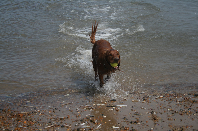
Sunday it was time to hit the beach with Jake and his ball- again, hot and sunny with perfect blue skies and white fluffy clouds... tried not to get too annoyed!

 Wells Beach
 The Pinewoods
Saturday morning I reinforced the compeed dressing with zinc oxide tape and headed down for a hearty breakfast. I was joined by a couple who told me that this was their fourth visit to the B and B; their first visit coincided with a hotel inspector's visit, and they were rather perturbed when he pulled out a metal probe and proceeded to check the temperature of his breakfast sausage!
The owners had kindly dried my shoes for me, and as my comfy socks were still wet I had to put on a pair of the new ones, but hoped that the dressing would keep them from rubbing too much. As I took my first tentative steps, the blisters and the ankle didn't feel too bad, and I hoped I was going to be able to keep my feet dry!
I reached the signpost marking the start of the Norfolk Coast Path;

I was still glad to see the now familiar sign post and stopped to fill my water bottle before heading away over the dunes on a track which soon became a boardwalk.


Thornham used to be a thriving port before it silted up and became un-navigable, and the old wooden posts and parts of jetties can still be seen rising out of the marsh like the ghosts of a prosperous past.

After Thornham the route turned inland, and followed a surprisingly busy road uphill for over a mile, before turning left through fields. It was dry but rather dull, and I must say this was the worst part of the day for me. I caught up and passed three walkers and eventually reached the pretty village of Brancaster. My feet were aching and I could have really done with a coffee, but was not yet half way so was determined to press on for as long as I could.
Finally I was walking near to the sea again, which lifted my spirits a little, on a boardwalk over marshy ground at the back of the village. This ran all the way to Brancaster Staithe;

Brancaster Staithe appears to have a working port and boasts a cluster of run down sheds, a 'crab shack' selling freshly caught seafood and a jumbled collection of old boats and lobster pots.


It also boasts a service station and cafe, so as I was struggling to put one foot in front of the other I crawled in, feeling like a wreck, and treated myself to a jacket potato and hot chocolate.
I left 30 minutes later, passing the three walkers I had walked past earlier who were obviously doing the same route as myself. I felt so much better, and even had a spring in my step, which was quite lucky as I had to run back to collect my route notes I had left on the counter at the cafe!
The next part of the route followed the giant curve of the sea wall around Deepdale Marsh to the village of Burnham Overy Staithe. I was treated to the flat horizons and big skies Norfolk is famous for, and could see the tiny figure of Overy Windmill in the distance. I could also see the golden sands of Holkham beach, my next destination. It seemed tantalisingly close, yet is separated by a treacherous stretch of marsh land which can't be crossed safely. My initial spring in the step had worn off by the time I reached the outskirts of the village, and I had to buy a Feast lolly from a handy ice cream van to keep me going.


The Coast Path now traversed the vast expanse of Holkam Beach; this was the part I had been dreading all day. I was really tired, my ankle was throbbing, my feet were really starting to protest that they had done quite enough, thank you, and I now had a two mile stretch over soft, shifting sand- lovely!
The official route follows a path through the dunes, but I did as my guidebook suggested and stuck to the tide mark where the sand was wetter and more compacted. Apparently part of this beach is a designated naturist reserve; luckily it was too cold for anyone to get their kit off and all I saw were a couple of dead seals and a portaloo (which I took advantage of!)

In fact, it was quite deserted and desolate, and by the time I reached Holkham Gap I just wanted to finish. Although I have walked the next part, the track by the pine woods to Wells, many times it seemed to take forever today. It had also started to rain so I was not a happy camper when I finally reached Pinewoods Caravan Park.
Overall I had made pretty good time, and covered 23 miles, but although the blisters were only voicing mild concern, my ankle was far from happy. In fact my mum took one look at the swollen mass that used to be a nicely turned ankle and suggested that maybe walking another 24 miles on it tomorrow would not be the best idea, and that maybe I should consider postponing the final day. She suggested a day in Sheringham instead, and although I knew that I could complete the walk if I really wanted to, I also knew that it wouldn't be fun, it would be very painful and a real slog, with the possibility of doing more serious damage to the ankle and being out of action for months. I was also particularly concerned that I would not reach Cromer before the last Coast Hopper back to Wells at 5:40pm, so gave in to the fleshpots of Sheringham and its pretty shops and coffee shops...
So although I have not actually completed my objective of walking the Peddars Way and Norfolk Coast Path in one go, I have completed the Peddars Way and have completed half of the coast path. As the second half starts from Wells, I can go back down at any time and complete the other half.
We did have a nice day in Sheringham, shopping and having lots of coffees (real hard work!) but rather annoyingly it was really sunny and hot! Typical... it was probably a good thing I chose to rest my ankle though as it was sore for around a week afterwards and I had to ice it each night to reduce the swelling. In fact I can still feel it at certain times now.
Sunday it was time to hit the beach with Jake and his ball- again, hot and sunny with perfect blue skies and white fluffy clouds... tried not to get too annoyed!


Labels: Norfolk Coast Path, Wells-Next-The-Sea
Wednesday, August 01, 2012
Peddars Way- Day Three
This was the final day of walking the Peddars Way, but I woke up seriously worried as my ankle was quite sore. I really thought I may have blown my chances of finishing but set to with an appetite at breakfast, listening to the rain pattering on the conservatory roof. The landlady informed me that the heavy showers were due to give way to lighter showers, and her husband cheerfully added that the jetstream was due to move at the weekend, giving sunny weather next week.
I set off into the grey gloom, which quickly gave way to showers. Mercifully my ankle wasn't too bad when I started to walk on it, and I had dressed my blisters so I started to feel slightly more hopeful and decided to take it slowly. I saw a dead snake on the road which looked as though it may have been an adder.


There are tumuli in the fields bordering the Peddars Way, and a stile allows access to one of them, but there is not a lot too see apart from a mound of earth.

Shortly afterwards the Way passes by the village of Bircham and I could see the distinctive windmill in the distance. There is a tea room here so I was sorely tempted, but as it would have added 3 miles into today's distance and I could feel my ankle again I thought it would not have been the greatest idea. I could see the broad grassy track of the Way stretching into the misty distance, and to the field on my right a deer was bounding through the crops, keeping pace with me.

The path now descended near to the village of Fring, where I met a chap cycling on his mountain bike. He said that he used to live in the area and asked me what the beginning of the Peddars Way was like as he'd like to cycle it. When I told him it was forest he seemed disappointed and said it sounded boring.

After a brief foray on the road, the path passes Sedgeford Magazine, an armoury built around 1640 and used in the Civil War.

By now my blisters were really hurting and I was dying for a coffee, but my guidebook informed me that the Gin Trap Inn in Ringstead wouldn't open until 6pm. However, I was mightily cheered when I finally descended to Ringstead to find a notice outside the pub stating it was open all day.
The landlord was leaning over the bar reading the paper, and I was the only customer, but he served me a lovely cup of coffee as it started raining again outside, Suitably refreshed, I set off through the village towards Holme-Next-The-Sea, walking across fields and down a muddy track to reach the final Songlife sculpture- 'And I being here have been part of all this caught and thrown like sun on water have entered into all around me.'


A final road walk bought me to the beach and golf course at Holme, and I could see my goal- a finger post marking the end of the Peddars Way and its junction with the Norfolk Coast Path.


I would have been so glad to finish here but had a tough walk through the dunes towards Hunstanton, following the Coast Path- it was hard going walking through sand and my feet kept slipping around inside my shoes, pulling my blisters even more.
I could see the cliffs of Hunstanton looking tiny in the distance, and it seemed to take an age to reach the lighthouse and the remaining wall of St Edmunds Chapel. St Edmund was the Christian king of East Anglia from around AD855, who's kingdom was devastated by Viking raids. Captured by the Danes in battle, he was tortured and executed, and according to legend he was beheaded and his head hidden so that he would be denied a Christian burial. His followers, searching for his head, heard the cries of a wolf shouting 'Here, here!' and found the wolf guarding his head.


The walk through Hunstanton was excruciating- my blisters were complaining very loudly indeed, especially the one on my left foot, and all my thoughts were directed towards reaching the B and B and assessing the damage. I eventually hobbled my way to the War Memorial and found the finger post marking the start of the Norfolk Coast Path, before treating myself to a portion of chips and staggering to the B and B.

The owners of the B and B, Deepdene, were lovely and insisted in bringing me a cup of tea and slice of cake when I arrived. They said that they have a lot of Peddars Way and Norfolk Coast Path walkers- every day during April but it rained all the time!
I had a bath and took stock of the damages. Ankle- rather swollen but not too sore. Blisters- not too bad on the right foot, one burst and angry looking blister on the left foot, with a large flap of loose skin. I snipped this away and dressed it with a compeed reinforced with Zinc Oxide tape, hoping that tomorrow would allow me to keep my feet dry and the dressings in place.
I decided that I would just take tomorrow as it comes and had an early night watching telly in bed with a mug of hot chocolate...
Labels: Hunstanton, Norfolk Coast Path, Peddars Way, Ringstead
![]()
