Wednesday, August 01, 2012
Peddars Way- Day Three
This was the final day of walking the Peddars Way, but I woke up seriously worried as my ankle was quite sore. I really thought I may have blown my chances of finishing but set to with an appetite at breakfast, listening to the rain pattering on the conservatory roof. The landlady informed me that the heavy showers were due to give way to lighter showers, and her husband cheerfully added that the jetstream was due to move at the weekend, giving sunny weather next week.
I set off into the grey gloom, which quickly gave way to showers. Mercifully my ankle wasn't too bad when I started to walk on it, and I had dressed my blisters so I started to feel slightly more hopeful and decided to take it slowly. I saw a dead snake on the road which looked as though it may have been an adder.


There are tumuli in the fields bordering the Peddars Way, and a stile allows access to one of them, but there is not a lot too see apart from a mound of earth.

Shortly afterwards the Way passes by the village of Bircham and I could see the distinctive windmill in the distance. There is a tea room here so I was sorely tempted, but as it would have added 3 miles into today's distance and I could feel my ankle again I thought it would not have been the greatest idea. I could see the broad grassy track of the Way stretching into the misty distance, and to the field on my right a deer was bounding through the crops, keeping pace with me.

The path now descended near to the village of Fring, where I met a chap cycling on his mountain bike. He said that he used to live in the area and asked me what the beginning of the Peddars Way was like as he'd like to cycle it. When I told him it was forest he seemed disappointed and said it sounded boring.

After a brief foray on the road, the path passes Sedgeford Magazine, an armoury built around 1640 and used in the Civil War.

By now my blisters were really hurting and I was dying for a coffee, but my guidebook informed me that the Gin Trap Inn in Ringstead wouldn't open until 6pm. However, I was mightily cheered when I finally descended to Ringstead to find a notice outside the pub stating it was open all day.
The landlord was leaning over the bar reading the paper, and I was the only customer, but he served me a lovely cup of coffee as it started raining again outside, Suitably refreshed, I set off through the village towards Holme-Next-The-Sea, walking across fields and down a muddy track to reach the final Songlife sculpture- 'And I being here have been part of all this caught and thrown like sun on water have entered into all around me.'


A final road walk bought me to the beach and golf course at Holme, and I could see my goal- a finger post marking the end of the Peddars Way and its junction with the Norfolk Coast Path.


I would have been so glad to finish here but had a tough walk through the dunes towards Hunstanton, following the Coast Path- it was hard going walking through sand and my feet kept slipping around inside my shoes, pulling my blisters even more.
I could see the cliffs of Hunstanton looking tiny in the distance, and it seemed to take an age to reach the lighthouse and the remaining wall of St Edmunds Chapel. St Edmund was the Christian king of East Anglia from around AD855, who's kingdom was devastated by Viking raids. Captured by the Danes in battle, he was tortured and executed, and according to legend he was beheaded and his head hidden so that he would be denied a Christian burial. His followers, searching for his head, heard the cries of a wolf shouting 'Here, here!' and found the wolf guarding his head.


The walk through Hunstanton was excruciating- my blisters were complaining very loudly indeed, especially the one on my left foot, and all my thoughts were directed towards reaching the B and B and assessing the damage. I eventually hobbled my way to the War Memorial and found the finger post marking the start of the Norfolk Coast Path, before treating myself to a portion of chips and staggering to the B and B.

The owners of the B and B, Deepdene, were lovely and insisted in bringing me a cup of tea and slice of cake when I arrived. They said that they have a lot of Peddars Way and Norfolk Coast Path walkers- every day during April but it rained all the time!
I had a bath and took stock of the damages. Ankle- rather swollen but not too sore. Blisters- not too bad on the right foot, one burst and angry looking blister on the left foot, with a large flap of loose skin. I snipped this away and dressed it with a compeed reinforced with Zinc Oxide tape, hoping that tomorrow would allow me to keep my feet dry and the dressings in place.
I decided that I would just take tomorrow as it comes and had an early night watching telly in bed with a mug of hot chocolate...
Labels: Hunstanton, Norfolk Coast Path, Peddars Way, Ringstead


Sunday, July 29, 2012
Peddars Way- Day Two
Day Two- Little Cressingham to Castle Acre- 12.5 miles;
After a suitably huge breakfast as befits an intrepid endurance walker I set off into grey cloud and the promise of drizzle. I thought that today would be the shortest an easiest day... I was wrong... instead it turned out to be the greatest threat to the whole walk!
If yesterday was dominated by forest walking, then today was all about road walking. I must admit that this first part of the Peddars Way isn't as interesting as the latter stages, and I probably wouldn't choose to walk it again.
 Road Walking
Luckily the roads were quiet- rabbits were scampering across the road and at one point a weasel dashed across in front of me. The Peddars Way is well sign posted and there are even signs pointing to local pubs off route, with distances and phone numbers so you can contact them to check that they are open.
 Sign Posts En Route
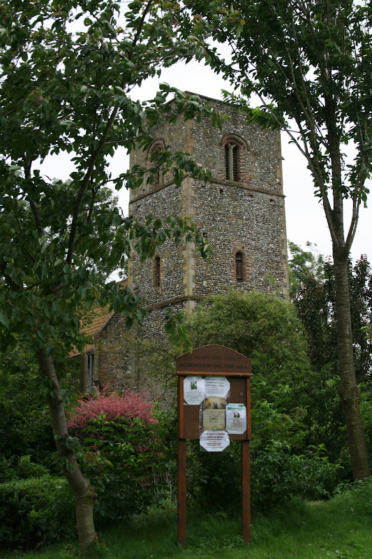
The church at the lost village of Houghton-on-the-Hill is just off route and apparently contains Roman frescoes, so I decided to take a look and turned off the main track into the drizzle. Unfortunately the church was locked so I didn't get to see the famous frescoes.
 Houghton-On-The-Hill Church
After rejoining the route it passed through fields, the original Roman road being lost here. Although it was pretty, the ground was very soggy and I could feel blisters developing on both feet as socks and shoes were wet through. I decided I had better try to sort it out and stopped at North Pickenham to dress my wounds.
 Cornfields And Wind Pumps
I sat on a handy bench and passed the time of day with an elderly lady with a wheelbarrow full of weeds. The route left the village- I couldn't resist a peep at a wooden Anglo Saxon warrior- and followed the line of an old railway.
 Anglo Saxon Warrior
 Old Railway Track
There was another Songline sculpture here- 'The piety of every man and every woman's whispered prayer clasped in the grain of wood and stone and in the grace of ancient air'.
 Songlife Sculpture
The track ended at the A47 and a McDonalds, where I allowed myself to be seduced by a Smarties McFlurry! Unfortunately it was quite showery and I could feel my dressings sliding around which certainly wasn't helping my blisters any.
The last part of today's walk was along more roads, although the path sometimes followed field headlands next to the road. I caught my first glimpse of Castle Acre through a gap in the hedge, with the castle ruins looming over the village.
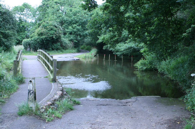
A ford allows entry to the village, although there is a bridge too so I didn't have to get my feet totally wet! The road into the village passes under Bailey Gate, part of the old castle fortifications.
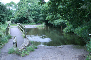
 Bailey Gate
As well as the castle ruins, there are also the ruins of a Cluniac Priory, a victim of Henry 8th's dissolution of the monasteries.
 I had a sandwich and coffee in The Ostrich Inn, and walked down the road towards the priory ruins. Unfortunately it started to rain quite fast, so I decided not to pay to look around the ruins but headed for the castle instead. I took some pictures, but it started to pour, so I took shelter in a handy sentry arch in the ruins of a gateway. It was coming down in torrents, so I sat it out in my shelter for 30 minutes, before it eased enough for me to find the Cost Cutter and the path to the B and B. Unfortunately my blisters were quite sore at this point, and I was becoming concerned as I still had the longest three days to go.
As I headed out of the village, the sun came out and it was lovely. After some deliberation I decided to head back and snap the castle ruins in the sunshine. As it turned out, I was to regret this decision!
 Castle Ruins


 The castle dates from the 11th century and was built by William de Warrene, the first Earl of Surrey, who also built the priory. The castle was remodelled during the 12th century and fell into disrepair after the Civil War.
I had just scrambled down a steep bank to take the above photo when my right foot slipped on something and I fell heavily onto my right side. Feeling a fool, I got to my feet and walked off but after a few steps it was apparent that I had done something to my right ankle.
I was in some discomfort when I finally arrived at the B and B. I had deliberately chosen one out of the village to shorten tomorrow's distance, and Wicken View fitted the bill nicely with a warm welcome. I had another lovely hot bath, as a terrific storm broke overhead.
My ankle felt quite sore during the night, and my blisters looked pretty bad too- I was feeling really concerned and rather worried about tomorrow's 22 miles...
If yesterday was dominated by forest walking, then today was all about road walking. I must admit that this first part of the Peddars Way isn't as interesting as the latter stages, and I probably wouldn't choose to walk it again.

Luckily the roads were quiet- rabbits were scampering across the road and at one point a weasel dashed across in front of me. The Peddars Way is well sign posted and there are even signs pointing to local pubs off route, with distances and phone numbers so you can contact them to check that they are open.

The church at the lost village of Houghton-on-the-Hill is just off route and apparently contains Roman frescoes, so I decided to take a look and turned off the main track into the drizzle. Unfortunately the church was locked so I didn't get to see the famous frescoes.
After rejoining the route it passed through fields, the original Roman road being lost here. Although it was pretty, the ground was very soggy and I could feel blisters developing on both feet as socks and shoes were wet through. I decided I had better try to sort it out and stopped at North Pickenham to dress my wounds.

I sat on a handy bench and passed the time of day with an elderly lady with a wheelbarrow full of weeds. The route left the village- I couldn't resist a peep at a wooden Anglo Saxon warrior- and followed the line of an old railway.


There was another Songline sculpture here- 'The piety of every man and every woman's whispered prayer clasped in the grain of wood and stone and in the grace of ancient air'.

The track ended at the A47 and a McDonalds, where I allowed myself to be seduced by a Smarties McFlurry! Unfortunately it was quite showery and I could feel my dressings sliding around which certainly wasn't helping my blisters any.
The last part of today's walk was along more roads, although the path sometimes followed field headlands next to the road. I caught my first glimpse of Castle Acre through a gap in the hedge, with the castle ruins looming over the village.
A ford allows entry to the village, although there is a bridge too so I didn't have to get my feet totally wet! The road into the village passes under Bailey Gate, part of the old castle fortifications.

As well as the castle ruins, there are also the ruins of a Cluniac Priory, a victim of Henry 8th's dissolution of the monasteries.

As I headed out of the village, the sun came out and it was lovely. After some deliberation I decided to head back and snap the castle ruins in the sunshine. As it turned out, I was to regret this decision!


I had just scrambled down a steep bank to take the above photo when my right foot slipped on something and I fell heavily onto my right side. Feeling a fool, I got to my feet and walked off but after a few steps it was apparent that I had done something to my right ankle.
I was in some discomfort when I finally arrived at the B and B. I had deliberately chosen one out of the village to shorten tomorrow's distance, and Wicken View fitted the bill nicely with a warm welcome. I had another lovely hot bath, as a terrific storm broke overhead.
My ankle felt quite sore during the night, and my blisters looked pretty bad too- I was feeling really concerned and rather worried about tomorrow's 22 miles...
Labels: Castle Acre, Peddars Way
Peddars Way- Day One
Day One- Knettishall Heath to Little Cressingham- 14.5 miles
It was an adventure in itself just getting to the start of the Peddars Way, as Knettishall Heath is off the beaten track and not generally served by public transport. I caught the Coast Hopper bus from Wells to Kings Lynn, the train from Kings Lynn to Thetford, changing at Ely, and then used the excellent Suffolk Links Brecks Bus to the start. This is an amazing service- bookable in advance, a minibus will collect you from the station and deposit you at Knettishall Heath, for the princely sum of £1.80.
The lady who collected me advised that it is a community service and that she collects people to take them to Day Centres etc, but like all public services it is under threat from Government cuts. It would be a great shame if it were lost.
The start of the Peddars Way is very unassuming- in the middle of forest, a solitary finger post next to a car park marks the way.
 I walked across the car park to look at the end of the Icknield Way, which ends at the start of the Peddars Way and chatted to two ladies who were planning on cycling the route and overnighting at Ringstead some 40 miles away.
The first part of the Peddars Way is through forest- lots and lots of forest! I set off down a somewhat muddy track which opened out into heathland known as The Brecks. It also starts in Suffolk although only for the first few hundred yards until the Little Ouse river is crossed.
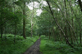
 The Brecks
This path was quite pleasant, winding through woodland, Breckland and past rivers. It was cloudy but stayed dry all day... my pack didn't feel too heavy at all and I felt quite positive.

 The Path Follows The Raised 'Agger' Of The Roman Road
The sun even made a rare appearance as I reached a car park at Roundall Heath and succumbed to a coffee from the burger van which appeared to be doing a roaring trade from passing truckers. I wasn't looking forwards to the next obstacle- a 100 metres dash over the A11 dual carriageway- but a few minutes later I was safely over and walking towards the village of Stonebridge. Or East Wretham, depending on which side of the road you are standing on apparently; I walked on both sides to maintain some impartiality.
There isn't a pub in Little Cressingham so I stopped for egg and chips at the Dog and Partridge;
 I didn't enjoy the path beyond the village. It followed a wide track through rather bleak forest, with army training ground to the left, with signs warning not to stray into this area. I did find the first of the 'Songlines' sculptures- these are a number of carved stone sculptures by Tom Perkins, featuring words from a book in an effort to link the present day Peddars Way with the past. The words are becoming less legible, but I could make them out- 'The footprints of our ancestors familiar as our own faces remote as fossils written on clay and washed away over and over, over and over'.
 The expanse of Thompson Water lies just off route, but I managed to miss it. Past this the path narrowed to a much more pleasant track which led me to the second Songlines sculpture, which read 'Surveyors have made their lives on the land trapping Albion in a net of roads a taut web on the edge of empire'.
 Finally the track left the woods, leading past a wide common and following farm tracks towards Little Cressingham. My socks, which I had bought new but were thicker than my usual ones, were rubbing my instep a little, but I felt otherwise okay. The road into the village is quite busy, but the Peddars Way followed tracks behind the hedgerow or along the verge. The sun was a welcome companion as I entered the village.
 Following The Hedgerow
I was quite early, so spotted the B and B and continued down the road to look at the church. It is quite spectacular- part of the church tower and chancel have collapsed, but the rest of the church is still very much in use.

 Little Cressingham Church
A little further down the road is a combined wind and water mill, which is in the process of being restored;

There is only one Bed and Breakfast on the route here- Sycamore House, which is right on the route. Although I had paid for a single I was upgraded to a twin, and had a lovely bubble bath. I had already eaten and had some snacks with me, although the owner offered to run me to Great Cressingham and the pub. As I surveyed my feet I noticed that I had a small blister from my socks, but otherwise felt in good shape and ready for tomorrow!
It was an adventure in itself just getting to the start of the Peddars Way, as Knettishall Heath is off the beaten track and not generally served by public transport. I caught the Coast Hopper bus from Wells to Kings Lynn, the train from Kings Lynn to Thetford, changing at Ely, and then used the excellent Suffolk Links Brecks Bus to the start. This is an amazing service- bookable in advance, a minibus will collect you from the station and deposit you at Knettishall Heath, for the princely sum of £1.80.
The lady who collected me advised that it is a community service and that she collects people to take them to Day Centres etc, but like all public services it is under threat from Government cuts. It would be a great shame if it were lost.
The start of the Peddars Way is very unassuming- in the middle of forest, a solitary finger post next to a car park marks the way.

The first part of the Peddars Way is through forest- lots and lots of forest! I set off down a somewhat muddy track which opened out into heathland known as The Brecks. It also starts in Suffolk although only for the first few hundred yards until the Little Ouse river is crossed.


This path was quite pleasant, winding through woodland, Breckland and past rivers. It was cloudy but stayed dry all day... my pack didn't feel too heavy at all and I felt quite positive.


The sun even made a rare appearance as I reached a car park at Roundall Heath and succumbed to a coffee from the burger van which appeared to be doing a roaring trade from passing truckers. I wasn't looking forwards to the next obstacle- a 100 metres dash over the A11 dual carriageway- but a few minutes later I was safely over and walking towards the village of Stonebridge. Or East Wretham, depending on which side of the road you are standing on apparently; I walked on both sides to maintain some impartiality.
There isn't a pub in Little Cressingham so I stopped for egg and chips at the Dog and Partridge;


I was quite early, so spotted the B and B and continued down the road to look at the church. It is quite spectacular- part of the church tower and chancel have collapsed, but the rest of the church is still very much in use.


A little further down the road is a combined wind and water mill, which is in the process of being restored;

There is only one Bed and Breakfast on the route here- Sycamore House, which is right on the route. Although I had paid for a single I was upgraded to a twin, and had a lovely bubble bath. I had already eaten and had some snacks with me, although the owner offered to run me to Great Cressingham and the pub. As I surveyed my feet I noticed that I had a small blister from my socks, but otherwise felt in good shape and ready for tomorrow!
Labels: Little Cressingham, Peddars Way, Stonebridge
Thursday, July 12, 2012
The Peddars Way And Norfolk Coast Path
The time is drawing ever nearer so I thought I'd just explain a little about the Peddar's Way and Norfolk Coast Path- which I attempt to complete next week.
They are essentially two routes in one. The Peddars Way starts at Knettishall Heath in Suffolk and ends at Holme-Next-The-Sea on the Norfolk Coast, where it joins the Norfolk Coast Path. The Peddars Way follows the route of a Roman Road, although the route is thought to have been in use long before the Romans arrived. The Romans built the road as one of the routes they established across East Anglia following the defeat of Boudicca and her tribe, the Iceni.
The Norfolk Coast Path is a newly created path, there is a detour to Hunstanton before following the coast to finish at Cromer. The Peddars Way is 46 miles long and the Norfolk Coast Path 47; including Hunstanton makes the total length 96 miles. Although most folks tend to take around 7-8 days to walk it, I am going to attempt to walk that path in 5...
Accommodation is scarce on the Peddars Way, unless you go off route, which has had an impact on where I stop for the night and which has meant that the distances I walk in a day vary quite considerably.
The first day I will walk 14.5 miles from Knettishall Heath to Little Cressingham. The second day is a short one- 12.5 miles to just beyond Castle Acre. I'm not too worried about this though as there's a lot to see in Castle Acre- castle ruins and an old Priory, so I'm sure I can have a mooch around for a few hours.
The third day will be a test- 22 miles to Hunstanton- the route is quite isolated and doesn't pass through any villages until Ringstead at 17 miles, unless I go off route. There are a few picturesque villages off route but it all adds distance to an already long day so realistically I probably won't visit them. I will reach the end of the Peddars Way and will overnight in Hunstanton- chips on the sea front will be in order I think!
The fourth day sees me walking 23 miles along the coast, through bustling fishing villages and along golden sands to mum's caravan at Wells-Next-The-Sea, and finally I have a final 24 miles on day five along coast and shingle bank to Cromer. I will be carrying all my stuff apart from the last day when I can leave it at the van and take a day pack...
Quite a schedule- I just hope I have done enough training and that my foot is not going to play up. Then there's the issue of the lovely weather we are having... I am hoping that Norfolk lives up to its reputation of being drier than the rest of the UK!
I'm getting quite excited now... in normal Steph style I have gone and booked myself a hilly 26 mile walk on Saturday (the White Peak) so- so much for the taper!
They are essentially two routes in one. The Peddars Way starts at Knettishall Heath in Suffolk and ends at Holme-Next-The-Sea on the Norfolk Coast, where it joins the Norfolk Coast Path. The Peddars Way follows the route of a Roman Road, although the route is thought to have been in use long before the Romans arrived. The Romans built the road as one of the routes they established across East Anglia following the defeat of Boudicca and her tribe, the Iceni.
The Norfolk Coast Path is a newly created path, there is a detour to Hunstanton before following the coast to finish at Cromer. The Peddars Way is 46 miles long and the Norfolk Coast Path 47; including Hunstanton makes the total length 96 miles. Although most folks tend to take around 7-8 days to walk it, I am going to attempt to walk that path in 5...
Accommodation is scarce on the Peddars Way, unless you go off route, which has had an impact on where I stop for the night and which has meant that the distances I walk in a day vary quite considerably.
The first day I will walk 14.5 miles from Knettishall Heath to Little Cressingham. The second day is a short one- 12.5 miles to just beyond Castle Acre. I'm not too worried about this though as there's a lot to see in Castle Acre- castle ruins and an old Priory, so I'm sure I can have a mooch around for a few hours.
The third day will be a test- 22 miles to Hunstanton- the route is quite isolated and doesn't pass through any villages until Ringstead at 17 miles, unless I go off route. There are a few picturesque villages off route but it all adds distance to an already long day so realistically I probably won't visit them. I will reach the end of the Peddars Way and will overnight in Hunstanton- chips on the sea front will be in order I think!
The fourth day sees me walking 23 miles along the coast, through bustling fishing villages and along golden sands to mum's caravan at Wells-Next-The-Sea, and finally I have a final 24 miles on day five along coast and shingle bank to Cromer. I will be carrying all my stuff apart from the last day when I can leave it at the van and take a day pack...
Quite a schedule- I just hope I have done enough training and that my foot is not going to play up. Then there's the issue of the lovely weather we are having... I am hoping that Norfolk lives up to its reputation of being drier than the rest of the UK!
I'm getting quite excited now... in normal Steph style I have gone and booked myself a hilly 26 mile walk on Saturday (the White Peak) so- so much for the taper!
Labels: Norfolk Coast Path, Peddars Way, White Peak
Saturday, July 07, 2012
Tough Training Weekend Continued...
So last Saturday I decided to park at Gunthorpe Locks, follow the River Trent to Fiskerton, include a loop further along the river and back towards Fiskerton and make my way back to Gunthorpe along bridlepaths. I tool my trusty Garmin with me and can accurately report I did 19.25 miles with a pack that was heavier than it is going to be on my walk.
My trusty camera, however, decided to stop working three quarters of the way round- the flash goes off but the shutter does'nt seem to actually open and so there is no picture. Although I was going to take my DSLR on my walk and my compact camera isn't needed, this means that I will still need to buy another at some point as I take it with me when I do the challenge walks.
Anyway, I set off along the river- mostly walking, and trying to set a good pace. The weather was mainly dry with a few showers, but I underestimated the sun and burnt my arms... even though I carried my sun cream with me all day and didn't use it. My right sole was a little sore from where my sock rubbed the day before, but I reinforced the compeed with some zinc oxide tape to keep it in place... and remembered that I had actually been carrying two pairs of spare socks with me the day before and so could have changed them at any point... can you see a theme here!!

 The River Trent Before Hoveringham
I made it to Hazelford Ferry in quite good time, but after this the paths became very muddy and slippery and I was quite glad not to be retracing my steps.

 The Weir At Hazelford Ferry- With Cormorant!
I passed a bench at Fiskerton and decided to complete the loop and then sit down and have my sandwich. This next stage was more difficult- my legs had already started to ache, my foot was hurting, the paths were rough and ill defined and it seemed to be a real struggle!

 Eel!
Eel!
I passed this strange looking beastie, which looked like an eel with a broken neck (assuming they have necks!)
I was mightily pleased to see my bench again and had a welcome sandwich. My legs were aching quite a lot now and my feet felt in need of a pumping up, so I explored Fiskerton and found a lovely little village shop that sold me painkillers and a Feast lolly!
This fortified me nicely, and I returned through fields to Hazelford Ferry and picked up the bridlepath across fields to Hoveringham. I decided to extend this further and pick up another, well maintained, bridleway to Hoveringham Mill, and turn down a footpath by the river to Caythorpe. However, the footpath was not maintained at all- I entered a field of sheep, saw a footpath and stile sign into the next field and noticed with some dismay that there was no path- the crops were right up to the field edge. I could see the road to Caythorpe to my right, so abandoned the path, walked down the sheep field and climbed out onto the road.
Caythorpe is a lovely little village- there was an old red telephone box which had been turned into a book library. I reached the point where the footpath I tried to follow met the road, and it looked as though I would still have been hacking my way through now!! It's a shame but I have emailed the rights of way devision at the Council who have agreed to look into this.
My legs and feet were really shouting at me now, luckily there was just a short hop (limp more like!!) through fields to Gunthorpe and the car- I did get some strange looks from all the day trippers when I crawled back to the car looking like nothing on earth!!
So I have now officially started to taper... I just hope I have done enough to complete the Peddars Way and Norfolk Coast Path!
My trusty camera, however, decided to stop working three quarters of the way round- the flash goes off but the shutter does'nt seem to actually open and so there is no picture. Although I was going to take my DSLR on my walk and my compact camera isn't needed, this means that I will still need to buy another at some point as I take it with me when I do the challenge walks.
Anyway, I set off along the river- mostly walking, and trying to set a good pace. The weather was mainly dry with a few showers, but I underestimated the sun and burnt my arms... even though I carried my sun cream with me all day and didn't use it. My right sole was a little sore from where my sock rubbed the day before, but I reinforced the compeed with some zinc oxide tape to keep it in place... and remembered that I had actually been carrying two pairs of spare socks with me the day before and so could have changed them at any point... can you see a theme here!!


I made it to Hazelford Ferry in quite good time, but after this the paths became very muddy and slippery and I was quite glad not to be retracing my steps.


I passed a bench at Fiskerton and decided to complete the loop and then sit down and have my sandwich. This next stage was more difficult- my legs had already started to ache, my foot was hurting, the paths were rough and ill defined and it seemed to be a real struggle!


I passed this strange looking beastie, which looked like an eel with a broken neck (assuming they have necks!)
I was mightily pleased to see my bench again and had a welcome sandwich. My legs were aching quite a lot now and my feet felt in need of a pumping up, so I explored Fiskerton and found a lovely little village shop that sold me painkillers and a Feast lolly!
This fortified me nicely, and I returned through fields to Hazelford Ferry and picked up the bridlepath across fields to Hoveringham. I decided to extend this further and pick up another, well maintained, bridleway to Hoveringham Mill, and turn down a footpath by the river to Caythorpe. However, the footpath was not maintained at all- I entered a field of sheep, saw a footpath and stile sign into the next field and noticed with some dismay that there was no path- the crops were right up to the field edge. I could see the road to Caythorpe to my right, so abandoned the path, walked down the sheep field and climbed out onto the road.
Caythorpe is a lovely little village- there was an old red telephone box which had been turned into a book library. I reached the point where the footpath I tried to follow met the road, and it looked as though I would still have been hacking my way through now!! It's a shame but I have emailed the rights of way devision at the Council who have agreed to look into this.
My legs and feet were really shouting at me now, luckily there was just a short hop (limp more like!!) through fields to Gunthorpe and the car- I did get some strange looks from all the day trippers when I crawled back to the car looking like nothing on earth!!
So I have now officially started to taper... I just hope I have done enough to complete the Peddars Way and Norfolk Coast Path!
Labels: Norfolk Coast Path, Peddars Way, river trent

