Friday, April 12, 2013
Event Report- The Three Shires Challenge
Oh this was a toughie!! I had originally hoped and trained to complete the full 29 miles... but it didn't go according to plan...
Saturday promised to be glorious and I witnessed a spectacular sunset as I drove my way through the Peaks towards Leek and Swythamley, the starting point of the walk. There didn't appear to be too much snow around so I looked forwards to a good day's walking although I wasn't too sure about my fitness.
After a cup of coffee I stepped out into glorious sunshine as we waited in the car park. We were officially started ('There's only 20 seconds to go so you may as well start now') and were starting the climb towards Gun Hill, and the trig point at the summit.
 It was here that we encountered the first patches of snow... but I naively thought that this would be all the snow we'd see...
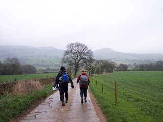
After Gun Hill there follows a long descent and then sharp ascent to the Roaches. I managed to fall over and turn my ankle not looking where I was going in an uneven field, but despite a few snow patches (surely the last ones we'd see...) the views were glorious and the weather was warm...

 Approaching The Roaches
The last part of the climb onto the Roaches is very steep and I was soon sweating and gasping for breath. There is a good path along the top and today the views were extensive... so much so that the huge white disc of Jodrell Bank could be seen.


 Views From The Roaches
A good path made of large stones lead down to the first checkpoint at Roach End and I happily jogged down it, feeling that I was making good progress. I stopped for a quick drink and a couple of biscuits before setting off and happily jogging downhill towards the woods.
Too late I realised that I was now trying to run on very slippery mud and soon went down on my arse! A nasty shock awaited us when we got to what I remembered to be a lovely little path descending steeply through woodland. It was still a little path, but due to the woods being quite sheltered it was now covered with ice... everyone seemed to come past me here as I found it really difficult. It took me ages to slither, crawl and wince my way down!
I was so relieved to reach the bottom and the track to Gradbach Youth Hostel, although the track now consisted of slippery wet mud and huge puddles filled with broken ice. The climb from Gradbach to Turn Edge and the track towards Three Shires Head was, although steep, without incident.
 I hoped that the track would be relatively snow and ice free. These hopes were not to be fulfilled... at one point I stepped in what I thought was a mere puddle but ended up nearly up to my waist in water, Vicar of Dibley style!
 Three Shires Head
I felt that I was losing a lot of time as I am terrible over tricky terrain! There was even more snow, which, in the heat of the day, was rapidly turning to slush, on the track towards Wildboarclough.
 Shutlingsloe 2- me 0
Loads more people came past me as I slowly slithered my way down the track, and on consulting my mobile realised that it was already 12:30pm so attempting the Shutlingsloe route would leave me with insufficient time to do the Cheshire Loop as well, especially given the conditions underfoot. So I turned away from the 'Matterhorn of Cheshire' and sought solace in the cheesy oatcakes on offer at the checkpoint at Wildboarclough.
I daren't linger too long of I intended to pull in the 7 mile Cheshire Loop, so after a coffee and a brief conversation with a chap who had lost the friend he'd been walking with, I set off, climbing through fields towards Oakenclough. I was grateful to lose the snow for a short while, although I did a lot of catching up with my old pal, slippery wet mud. Before dropping down to Pot Lords there is am amazing view right over Macclesfield and beyond.
 The next path goes through farmland and I remembered it being a little muddy last year, and so correctly guessed that this year it would be a lot muddy... I got to say hi to the snow again too as I fell over sideways into it! I got a little lost and ended up clambering ungainly over a gate, before the gradual muddy and slippery descent back towards Wildboarclough.


 Views From The Cheshire Loop
There doesn't look a lot of snow in those photos, but it's deceptive as it had stayed in sheltered spots, and along tracks and low lying areas. It seemed strange walking in warm sunshine but crunching through snow...
Tucking into another delicious oatcake I realised that I only had 3 hours to cover the remaining 7 miles back to Swythamley before the cut off time of 11 hours, so hauled my weary carcass onwards. I wasn't the last, surprisingly- I heard someone say they had another 10 to come in from the Cheshire Loop.
As I started the muddy climb onto the moors leading to Gradbach I caught up with two chaps who appeared to be walking at my speed and stuck with them for the rest of the walk. I wasn't at all surprised by now to find the track kept disappearing under deep snow, water and slippery mud and decided that I had had enough and prayed for a drought this year.

 The Track to Gradbach
After negotiating a slippery descent to the Youth Hostel and retracing our steps through the mud, the steep climb through the woods past Lud's Church wasn't too bad. I though we had maybe seen the last of the snow... until the steep descent to Danebridge which was completely covered in snow and ice. If I had been on my own I would have been cursing but as I had company I had to pick my way down in fed up silence. My legs were aching quite nicely at this point and I could feel a blister rubbing as my already soaked feet were pushed against the edge of my shoe by yet another sideways slide.
It was such a relief to reach the road and the track past the Trout Farm and brewery at Wincle. All that was left was a last steep climb and then the long track back to Swythamley.
 The Weir At Wincle
A friend of the two chaps I was walking with came to meet them (he was well into his 70s and had finished the walk some time before!) He reassured us that there was plenty of food left and we reached the village as the hills were lit up with the golden light of evening.
 We finished with 5 minutes to spare- 10 hours 55 minutes, although the chap had told us that the organisers had realised that they had to extend the deadline as the conditions underfoot were slowing everyone up. A week or so earlier and I think the event may have been in jeopardy.
We did some serious damage to the lovely salads that had been prepared- the food is truly superb on this walk. Despite the snow and slippery mud (did I mention that?) it was a great day and tremendous effort by the Staffordshire LDWA.
... next year I will do the full 29 miles...
Saturday promised to be glorious and I witnessed a spectacular sunset as I drove my way through the Peaks towards Leek and Swythamley, the starting point of the walk. There didn't appear to be too much snow around so I looked forwards to a good day's walking although I wasn't too sure about my fitness.
After a cup of coffee I stepped out into glorious sunshine as we waited in the car park. We were officially started ('There's only 20 seconds to go so you may as well start now') and were starting the climb towards Gun Hill, and the trig point at the summit.

After Gun Hill there follows a long descent and then sharp ascent to the Roaches. I managed to fall over and turn my ankle not looking where I was going in an uneven field, but despite a few snow patches (surely the last ones we'd see...) the views were glorious and the weather was warm...


The last part of the climb onto the Roaches is very steep and I was soon sweating and gasping for breath. There is a good path along the top and today the views were extensive... so much so that the huge white disc of Jodrell Bank could be seen.


A good path made of large stones lead down to the first checkpoint at Roach End and I happily jogged down it, feeling that I was making good progress. I stopped for a quick drink and a couple of biscuits before setting off and happily jogging downhill towards the woods.
Too late I realised that I was now trying to run on very slippery mud and soon went down on my arse! A nasty shock awaited us when we got to what I remembered to be a lovely little path descending steeply through woodland. It was still a little path, but due to the woods being quite sheltered it was now covered with ice... everyone seemed to come past me here as I found it really difficult. It took me ages to slither, crawl and wince my way down!
I was so relieved to reach the bottom and the track to Gradbach Youth Hostel, although the track now consisted of slippery wet mud and huge puddles filled with broken ice. The climb from Gradbach to Turn Edge and the track towards Three Shires Head was, although steep, without incident.


I felt that I was losing a lot of time as I am terrible over tricky terrain! There was even more snow, which, in the heat of the day, was rapidly turning to slush, on the track towards Wildboarclough.

Loads more people came past me as I slowly slithered my way down the track, and on consulting my mobile realised that it was already 12:30pm so attempting the Shutlingsloe route would leave me with insufficient time to do the Cheshire Loop as well, especially given the conditions underfoot. So I turned away from the 'Matterhorn of Cheshire' and sought solace in the cheesy oatcakes on offer at the checkpoint at Wildboarclough.
I daren't linger too long of I intended to pull in the 7 mile Cheshire Loop, so after a coffee and a brief conversation with a chap who had lost the friend he'd been walking with, I set off, climbing through fields towards Oakenclough. I was grateful to lose the snow for a short while, although I did a lot of catching up with my old pal, slippery wet mud. Before dropping down to Pot Lords there is am amazing view right over Macclesfield and beyond.


There doesn't look a lot of snow in those photos, but it's deceptive as it had stayed in sheltered spots, and along tracks and low lying areas. It seemed strange walking in warm sunshine but crunching through snow...
Tucking into another delicious oatcake I realised that I only had 3 hours to cover the remaining 7 miles back to Swythamley before the cut off time of 11 hours, so hauled my weary carcass onwards. I wasn't the last, surprisingly- I heard someone say they had another 10 to come in from the Cheshire Loop.
As I started the muddy climb onto the moors leading to Gradbach I caught up with two chaps who appeared to be walking at my speed and stuck with them for the rest of the walk. I wasn't at all surprised by now to find the track kept disappearing under deep snow, water and slippery mud and decided that I had had enough and prayed for a drought this year.


After negotiating a slippery descent to the Youth Hostel and retracing our steps through the mud, the steep climb through the woods past Lud's Church wasn't too bad. I though we had maybe seen the last of the snow... until the steep descent to Danebridge which was completely covered in snow and ice. If I had been on my own I would have been cursing but as I had company I had to pick my way down in fed up silence. My legs were aching quite nicely at this point and I could feel a blister rubbing as my already soaked feet were pushed against the edge of my shoe by yet another sideways slide.
It was such a relief to reach the road and the track past the Trout Farm and brewery at Wincle. All that was left was a last steep climb and then the long track back to Swythamley.

A friend of the two chaps I was walking with came to meet them (he was well into his 70s and had finished the walk some time before!) He reassured us that there was plenty of food left and we reached the village as the hills were lit up with the golden light of evening.

We did some serious damage to the lovely salads that had been prepared- the food is truly superb on this walk. Despite the snow and slippery mud (did I mention that?) it was a great day and tremendous effort by the Staffordshire LDWA.
... next year I will do the full 29 miles...
Labels: Peak District, Three Shires Challenge
Thursday, December 13, 2012
A Really Long Overdue Update!
I have not updated this blog for far too long! And shall we just say my exercise routine has been somewhat sporadic. Oh it has existed... just not as much or as consistently as it should have done.
I have entered the 21st Century and made my first foray into the Smartphone world, and I think I am just about getting used to it- even if I did manage to get the predictive text function in French earlier.It takes pretty good photos, almost makes taking my camera out with me redundant!
 The Woods near Holme Pierrepont- Taken By My Phone!
Next year I intend to blast off with some proper training and have already entered a couple of events to spur me on... I have entered the Three Shires Challenge again and would love to include the Shutlingsloe loop this time and complete the full 29 miles.
I suddenly realised I hadn't got around to entering the Belvoir Challenge, which is a must do event for me and usually the first one of the year! It usually fills up really quickly- round about now in fact- so not wanting to take any chances and trust the dodgy Royal Mail this near to Christmas I drove over to Harby and hand delivered my entry!
I would love to do a longer challenge next year- say a 40 miler, oh yes there's the Bullock Smithy as well... watch this space! I promise that next year is going to be a lot more eventful than this year turned out to be!!
I have entered the 21st Century and made my first foray into the Smartphone world, and I think I am just about getting used to it- even if I did manage to get the predictive text function in French earlier.It takes pretty good photos, almost makes taking my camera out with me redundant!

Next year I intend to blast off with some proper training and have already entered a couple of events to spur me on... I have entered the Three Shires Challenge again and would love to include the Shutlingsloe loop this time and complete the full 29 miles.
I suddenly realised I hadn't got around to entering the Belvoir Challenge, which is a must do event for me and usually the first one of the year! It usually fills up really quickly- round about now in fact- so not wanting to take any chances and trust the dodgy Royal Mail this near to Christmas I drove over to Harby and hand delivered my entry!
I would love to do a longer challenge next year- say a 40 miler, oh yes there's the Bullock Smithy as well... watch this space! I promise that next year is going to be a lot more eventful than this year turned out to be!!
Labels: Belvoir Challenge, Three Shires Challenge
Monday, April 02, 2012
The Three Shires Challenge- Event Report
This was a bit of a bonus event for me, as it was actually full when I went to enter it, but I asked whether I could be added to the waiting list and behold- a place became free at the last minute, so a huge thanks for the Staffs LDWA Group for fitting me in!
After a week of gorgeous sunshine it was a little disappointing to be heading out into mist and cloud... the journey was fairly uneventful apart from me thinking I had missed the turning to Swythamley and heading off down a country lane to be surprised by a large shape looming in front of me which turned out to be a red deer.
I found Swythamley and Heaton Village Hall and checked in, with plenty of time for a hot cuppa. I met up with Ross again and we walked together, which was great- having someone to chat to makes the miles go by much faster, especially towards the end when everything starts to ache!
We all gathered outside in the mist and drizzle and then we were on our way, walking up tracks to the first (of many!) climbs towards Gun Hill.
 Looking Towards The Roaches From Gun Hill
There is a choice of 20, 22, 27 or 29 miles, and you can choose what you intend to do on the day, when you reach the 13 mile check point at Wildboarclough. I had originally entertained idle thoughts of doing the 29 mile option, but those extra 2 miles involve and ascent and descent of Shutlingsloe, which is not called the 'Cheshire Matterhorn' for nothing! The more miles we trudged, the more convinced I became that it was not a good idea... rightly so as it turned out!
After Gun Hill, we turned towards the spine of rock formations that make up the Roaches;

As we approached, the mist began to clear; although it was cloudy there were some pretty awesome views. The climb up onto the Roaches was a bit of a shock but spectacular- the lanscape consisted of oddly shaped flat stacks of rocks and huge boulders that had been dumped there by the retreating glaciers of the last ice age.
 View Over Tittesworth Reservoir

 Typical Roaches Scenery
After a particularly steep pull up onto the top, I suddenly felt very odd- very dizzy and 'unreal' and as though I could just pass out. I've not had that feeling very often but it was horrid and for a short time I was worried about being able to do the rest of the walk. After Ross' kindly administration of jelly babies and a few generous gulps of water the feeling went as suddenly as it came and I felt fine for the rest of the day. The runners were passing us, and we shouted hi to Rich (Desert Racer) as he ran past.
I stocked up on biscuits and jelly babies at the first checkpoint at the foot of The Roaches- it was an exposed spot and I felt rather sorry for the people manning it! The wind was really quite chilly. Fortunately we dropped down into the forest and lost the wind, following a truly lovely path through the trees towards Gradbach Youth Hostel- I had last been here when attempting the now sadly deceased Leek Moors Marathon...
After Gradbach there was more climbing, through some steep fields towards the track which leads to Three Shires Head;

We were heading into some pretty spectacular scenery now- very wild and remote. The packhorse bridge at Three Shires Head is the meeting point for Derbyshire, Cheshire and Staffordshire and this was my first visit- but I'm sure it won't be my last!


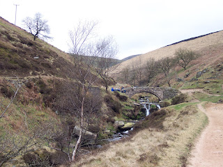 Three Shires Head
We were faced with more climbing and then a gradual descent on a rocky track towards Wildboarclough.

It was here that I got my first proper look at Shutlingsloe, which fully made up my mind not to attempt it this year... maybe next year when I am fitter!
 Shutlingsloe
The 13 mile checkpoint at Wildboarclough was a very welcome sight, made even more so by the fact that their speciality is oatcakes (resembling mini pancakes) stuffed with grated cheese and then heated til the cheese melts... I can't believe how good they tasted and had to have another one just to check...
We chose to take the 7 mile Cheshire Loop option- there was obviously another event going on as we kept seeing scouts walking the other way, I think they were doing an event called the Cheshire Hike. We also saw a couple of lads doing their Duke of Edinburgh award which was great.

The scenery was still splendid, and at the top of one climb we could see for miles, even picking out the huge white disc of Jodrell Bank.

This was followed by more fields and tracks before returning to Wildboarclough for more oatcakes (wouldn't want them to have too many left over now!!)
 Shutlingsloe
The last part of the route was 7 miles back to Swythamley, and we thought we were on the homeward stretch... the sun came out but I was feeling too tired to really appreciate it as we were faced with yet more climbing...
 There were some stunning views towards the Roaches and it felt as though we were in the middle of nowhere. I would love to wake up to a view like this!

After reaching Gradbach for a second time, we had a long, slow climb through the forest before reaching a long, long track winding its way along the lower reaches of the Roaches.
After what seemed an age, we dropped steeply down through woods to the quaint Wincle Brewery and Trout Farm.

After what would have been a pleasant walk through meadows if my body wasn't pleading for this to just stop now please, we reached a footbridge over the weir and what the route description cheerfully referred to as a 'steep climb'. Unfortunately it wasn't lying.
 I thought we must be nearly there, but we were faced with a long, long, lo-o-ong farm track with a great retrospective view;
 We both felt that this section felt much longer than 7 miles... but all things must come to an end and it was a relief to see the Village Hall again and to be greeted by a fantastic array of salads, quiche and pudding- I think this must have been the best meal I have ever had after a challenge walk! Feeling pretty full, I set off for home only to realise a mile down the road that I had forgotten to pick up my certificate so had to turn back- I didn't want to leave that behind, it took some getting!
This was a tough, but fantastic, event, and one which I would love to do again... maybe the 29 mile option next year!!
After a week of gorgeous sunshine it was a little disappointing to be heading out into mist and cloud... the journey was fairly uneventful apart from me thinking I had missed the turning to Swythamley and heading off down a country lane to be surprised by a large shape looming in front of me which turned out to be a red deer.
I found Swythamley and Heaton Village Hall and checked in, with plenty of time for a hot cuppa. I met up with Ross again and we walked together, which was great- having someone to chat to makes the miles go by much faster, especially towards the end when everything starts to ache!
We all gathered outside in the mist and drizzle and then we were on our way, walking up tracks to the first (of many!) climbs towards Gun Hill.

There is a choice of 20, 22, 27 or 29 miles, and you can choose what you intend to do on the day, when you reach the 13 mile check point at Wildboarclough. I had originally entertained idle thoughts of doing the 29 mile option, but those extra 2 miles involve and ascent and descent of Shutlingsloe, which is not called the 'Cheshire Matterhorn' for nothing! The more miles we trudged, the more convinced I became that it was not a good idea... rightly so as it turned out!
After Gun Hill, we turned towards the spine of rock formations that make up the Roaches;


As we approached, the mist began to clear; although it was cloudy there were some pretty awesome views. The climb up onto the Roaches was a bit of a shock but spectacular- the lanscape consisted of oddly shaped flat stacks of rocks and huge boulders that had been dumped there by the retreating glaciers of the last ice age.


After a particularly steep pull up onto the top, I suddenly felt very odd- very dizzy and 'unreal' and as though I could just pass out. I've not had that feeling very often but it was horrid and for a short time I was worried about being able to do the rest of the walk. After Ross' kindly administration of jelly babies and a few generous gulps of water the feeling went as suddenly as it came and I felt fine for the rest of the day. The runners were passing us, and we shouted hi to Rich (Desert Racer) as he ran past.
I stocked up on biscuits and jelly babies at the first checkpoint at the foot of The Roaches- it was an exposed spot and I felt rather sorry for the people manning it! The wind was really quite chilly. Fortunately we dropped down into the forest and lost the wind, following a truly lovely path through the trees towards Gradbach Youth Hostel- I had last been here when attempting the now sadly deceased Leek Moors Marathon...
After Gradbach there was more climbing, through some steep fields towards the track which leads to Three Shires Head;

We were heading into some pretty spectacular scenery now- very wild and remote. The packhorse bridge at Three Shires Head is the meeting point for Derbyshire, Cheshire and Staffordshire and this was my first visit- but I'm sure it won't be my last!


We were faced with more climbing and then a gradual descent on a rocky track towards Wildboarclough.

It was here that I got my first proper look at Shutlingsloe, which fully made up my mind not to attempt it this year... maybe next year when I am fitter!

The 13 mile checkpoint at Wildboarclough was a very welcome sight, made even more so by the fact that their speciality is oatcakes (resembling mini pancakes) stuffed with grated cheese and then heated til the cheese melts... I can't believe how good they tasted and had to have another one just to check...
We chose to take the 7 mile Cheshire Loop option- there was obviously another event going on as we kept seeing scouts walking the other way, I think they were doing an event called the Cheshire Hike. We also saw a couple of lads doing their Duke of Edinburgh award which was great.

The scenery was still splendid, and at the top of one climb we could see for miles, even picking out the huge white disc of Jodrell Bank.

This was followed by more fields and tracks before returning to Wildboarclough for more oatcakes (wouldn't want them to have too many left over now!!)

The last part of the route was 7 miles back to Swythamley, and we thought we were on the homeward stretch... the sun came out but I was feeling too tired to really appreciate it as we were faced with yet more climbing...


After reaching Gradbach for a second time, we had a long, slow climb through the forest before reaching a long, long track winding its way along the lower reaches of the Roaches.
After what seemed an age, we dropped steeply down through woods to the quaint Wincle Brewery and Trout Farm.

After what would have been a pleasant walk through meadows if my body wasn't pleading for this to just stop now please, we reached a footbridge over the weir and what the route description cheerfully referred to as a 'steep climb'. Unfortunately it wasn't lying.


This was a tough, but fantastic, event, and one which I would love to do again... maybe the 29 mile option next year!!
Labels: Three Shires Challenge
![]()
